THE BOOK
Some of the ideas discussed in this blog are published in my new book called "The Stonehenge Bluestones" -- available by post and through good bookshops everywhere. Bad bookshops might not have it....
To order, click
HERE

Saturday 31 August 2024

New Orkney Altar Stone paper -- yet more sampling bias


This is the geological map of Orkney Mainland, showing the main outcropping rock types (Lower and Upper Stromness Formations), directions of known ice movement during the last glacial episode, and the locations of the Ring of Brodgar and the Stones of Stenness.

As mentioned in the previous post, Bevins et al (2024) failed to find any match between the Stonehenge Altar Stone and the two famous standing stone settings.  They also failed to find any match with the Vestrafiold "Quarry" -- although establishing that must have been one of their research priorities.  

The researchers were also keen to establish that the standing stones were obtained or "sourced" from locations to the west or north-west, so ten of their chosen sampling locations were down-glacier.  This of course matches the prevailing wisdom -- the copious literature on the standing stone settings and on the Ness of Brodgar is full of assumptions that the stones were specially chosen and quarried before being hauled to their places of use.

This interpretation is countered by Adrian Hall and John Brown in their Orkney video, and by John Brown in this short article:

https://www.ssns.org.uk/wp-content/uploads/2019/08/13_Brown_Orkney_2003_pp_175-195.pdf

So why did the researchers fail to take any samples from the up-glacier outcrops of the Upper Stromness Formation and only three (5512, 5513 and 5514) from other formations?  The reason must be that they were afraid that they might prove that the stones were all glacial erratics!

Actually I am not that bothered with the glacial transport theory -- since it is pretty obvious from the geological map that all of the stones could have been locally derived from adjacent outcrops of the Lower and Upper Stromness beds.

This is all a bit of a farce.  However, we have learned some things from it that are quite useful.

1.  There are no similarities between the Stonehenge bluestone monoliths and the stones exposed on Orkney.

2.  The Altar Stone has not come from Orkney after all.

3.  There is nothing special about the monoliths at the Ring of Brodgar and the Stones of Stenness.  There is no reason for them to have been "fetched" from anywhere else on Orkney Mainland.

4.  Since there is no apparent geochemical or petrographic link between Vestrafiold and the Orkney standing stone sites, the idea of Neolithic quarrying at Vestrafiold and elsewhere can now be abandoned.  The evidence for the Vestrafiold quarry never was very strong anyway........

https://brian-mountainman.blogspot.com/2014/01/ring-of-brodgar-and-its-quarry.html

5.  As with the building complex at the Ness of Brodgar, where a wonderful local resource of exposed flagstones was used locally, it appears that the standing stone monuments were also built in the places where abundant suitable stones were to be found.  This was also the situation at Callanish:

https://brian-mountainman.blogspot.com/2014/06/callanish-and-its-standing-stones.html


The Ness of Brodgar -- perfect flagstones locally sourced and locally used......


Yesterday: the Altar Stone came from Orkney. Today: the Altar Stone did not come from Orkney


Sampled locations (green dots) on Orkney.  The Ring of Brodgar and the Stenness standing stones lie within the green box.

You could not make it up.  Yet again, powerful bias and a wilful refusal to examine physical processes.

Yesterday, Bevins, Ixer, Pearce et al said that the Altar Stone came from Orkney, and today (in a new paper) they say that it did not.  Archaeology is already in the doldrums because of all the fantastical claims of MPP and his merry men, and now geology appears to be on the slide as well -- demonstrating to the world that publication is all that matters and that thinking is out of fashion.

Here are the details:

Was the Stonehenge Altar Stone from Orkney? 2024
Bevins, Richard; Pearce, Nick; Hillier, Stephen; Pirrie, Duncan; Ixer, Rob A.; Andò, Sergio; Barbarano, Marta; Power, Matthew R.; Turner, Peter
Journal of Archaeological Science: Reports, 58

DOI:10.1016/j.jasrep.2024.104738

Citation:
Bevins, R., Pearce, N., Hillier, S., Pirrie, D., Ixer, R. A., Andò, S., Barbarano, M., Power, M. R., & Turner, P. (2024). Was the Stonehenge Altar Stone from Orkney? Investigating the mineralogy and geochemistry of Orcadian Old Red sandstones and Neolithic circle monuments. Journal of Archaeological Science: Reports, 58, Article 104738. Advance online publication. https://doi.org/10.1016/j.jasrep.2024.104738


ABSTRACT

Recent petrological, mineralogical and geochemical investigations of the Stonehenge Altar Stone have negated its source in the Old Red Sandstone (ORS) Anglo-Welsh Basin. Further, it has been suggested that it is time to look wider, across northern Britain and Scotland, especially in areas where geological and geochemical evidence concur, and there is evidence of Neolithic communities and their monuments. In this context the islands of Orkney, with its rich Neolithic archaeology, are an obvious area worthy of investigation. The same techniques applied to investigations of the Altar Stone and ORS sequences in southern Britain have been applied to two major Neolithic monuments on Mainland Orkney, namely the Stones of Stenness and the Ring of Brodgar. In addition, field samples of ORS lithologies from the main stratigraphic horizons on Mainland Orkney have been investigated.

Portable XRF analyses of the five exposed stones at the Stones of Stenness and seven of the exposed stones at the Ring of Brodgar show a wide range of compositions, having similar compositions to field samples analysed from both the Lower and Upper Stromness Flagstone formations, with the stones at Stenness appearing to have been sourced from the Upper Stromness Flagstone Formation while the Ring of Brodgar stones possibly being sourced from both formations. Examination of the mineralogy of ORS field samples and the Stonehenge Altar Stone, using a combination of X-ray diffraction, microscopy, Raman spectroscopy and automated SEM-EDS shows there to be no match between the Orkney samples and the Altar Stone. Only two samples from Orkney showed the presence of baryte, a characteristic mineral of the Altar Stone. Another key discriminant is the presence of abundant detrital K-feldspar in all of the Orkney field samples, a mineral which has only very low abundance in the Altar Stone. In addition, the regularly interstratified dioctahedral/dioctahedral smectite mineral tosudite is present in the clay mineral assemblage of the Altar Stone, but not detected in the Orkney samples.

It is concluded that the Altar Stone was not sourced from Mainland Orkney, despite considerable evidence for long-distance communications between Orkney and Stonehenge around 3000/2900 BCE.

============================

I have only had time for a brief reading so far, but as usual when I am reading articles by these geologists, I find myself shouting at the computer.  

The authors refer to the "date of arrival" of the bluestones at Stonehenge, with no consideration of the possibility that they might have come from an erratic cluster.  The paper is very technological (as distinct from very scientific), concentrating on pXRF readings on the stones at the Ring of Brodgar and the Stones of Stenness.  They decide that there is "no match between the Orkney samples and the Altar Stone"  -- using Altar Stone readings already published.  They refer over and again to the builders of the monuments "sourcing" (or fetching) the stones they needed,  and there are several mentions of the Vestrafiold Quarry and other putative quarries -- without ever seeking to prove that there was a quarry or that the stones could have been picked up from a ore-existing scatter of glacial erratics.  They say that 7 of the Ring of Brodgar stones show "a wide range of compositions, having similar compositions to field samples analysed from both the Lower and Upper Stromness Flagstone formations, with the 5 stones at Stenness appear to have been sourced from the Upper Stromness Flagstone Formation.  There ios no geology map or glaciation map.  As far as I can see, there is no mention anywhere in the artricle of ice movement directions or erratic transport, given that the ice flow across the island was from SE towards NW.  Also, there seems to be no attempt to differentiate between samples actually taken from the Altar Stone and samples from fragments assumed to have come from the Altar Stone.  That's not good enough.  Then they say there is  ".......considerable evidence for long-distance communications between Orkney and Stonehenge around 3000/2900 BCE".  That's a travesty.  As far as I can see, there is no evidence at all to support the idea of a 700 km sea or land transport effort involving a 6 tonne lump of rock.

It is extraordinary in this day and age that a group of senior geologists can discuss in a learned paper the sourcing of some very famous Orkney standing stones without once mentioning glaciation or erratic transport!  Do these people ever look at the landscape or consider landscape or landform surface processes?  

Whatever next, I wonder?

=============


https://www.researchgate.net/publication/309242436_The_last_glaciation_in_Orkney_Scotland_glacial_stratigraphy_event_sequence_and_flow_paths

The last glaciation in Orkney, Scotland: glacial stratigraphy, event sequence and flow paths
October 2016
Adrian M. Hall, James B. Riding and John Flett Brown
Scottish Journal of Geology 52(2) DOI: 10.1144/sjg2016-002

https://brian-mountainman.blogspot.com/2023/04/did-vestra-fiold-quarry-provide.html

Friday 30 August 2024

Science and the elusive truth


This quote from Richard Horton goes back a long way.  He was of course talking mostly about medical research, but I think we can see a close parallel in the research on Stonehenge and the bluestones, can't we?

Of course, no science can ever be completely true -- by its very nature it is incremental.

Monday 26 August 2024

East coast tills and erratics

Erratic pebbles from the East Yorkshire coast, found in till deposits.

Here is some of the raw material consulted by Matt Sibson and others during their assessments of the "Altar Stone Transport Debate".   The article by Sutherland et al (2020) attempts to elucidate the sequence of events near Tunstall at the end of the Devensian glaciation -- and the work demonstrates that while most of the glacial erratics have not travelled far, some have come from Scotland and even Scandinavia.  Also, the clasts have had complex histories, moved back and forth during a number of glacial episodes.

==========

A litho-tectonic event stratigraphy from dynamic Late Devensian ice flow of the North Sea Lobe, Tunstall, east Yorkshire, UK. 2020
Jenna L. Sutherland, Bethan J. Davies, Jonathan R. Lee
Proceedings of the Geologists' Association

NEW | Stonehenge Altar Stone 500 MILE Journey: Did Humans REALLY Move it?


Just came across this video, which is worth sharing.  Matt Sibson has an enquiring mind, and he has done a lot of hard work on the graphics and on hunting down the relevant literature.  The adverts that pepper the video are irritating, but such is the way with YouTube these days........

He makes some very sound points, and as he says, the North Sea glacial transport route needs to be explored.  I agree with him that a glacial route southwards along the Hebridean (west) coast of Scotland is vanishingly unlikely.   He assumes that the provenancing of the Altar Stone to NE Scotland is correct -- and that's where I differ with him, since I think it's probably wrong.  But this is serious and well researched SCRUTINY of an interesting and possibly crazy hypothesis, and that has to be commended......

Saturday 24 August 2024

Stirrings in the undergrowth


Jacky Henderson, presenter and maker of the YouTube video entitled 
"The Stonehenge Bluestone Debate"

In spite of the extraordinary media coverage for the absurd "Scottish Altar Stone"story, it's becoming clear that the members of the general public are less gullible than they appear at first sight.  Two bits of evidence.  One is the YouTube video made by Coral and Jacky and published two weeks ago.  It has had 67,000 views and attracted 558 comments so far -- the great majority of them expressing real concern about the work of MPP and his team, and about that infamous "Lost Circle" programme shown over and again by the BBC.

https://youtu.be/GoobiRgv50g?si=R6hhyQQNKjTn5jHM

The other bit of evidence comes from a short Linkedin post which I published a week ago on the problems associated with the "Scottish Altar Stone" paper in "Nature." A successful post on Linkedin might attract 100 viewings -- but for this post there have already been over 45,000 viewings and 48 comments.

It's clear that there is a lot of "word of mouth" promotion going on, completely out of the control of those of us who did the posting!   Many of the comments are coming from people with scientific backgrounds including some who know rather a lot about zircon and geological dating methods.

So well over 100,000 people have now come to realise that the story of the Stonehenge bluestones is not quite as reliable as certain academics would have them believe.  And it ain't over yet.

All in all, this has quite restored my faith in humanity...!

---------------


PS. I had this titled "mumblings in the undergrowth" as a picturesque expression,  but realised that this could be construed as referring to Jacky walking along his leafy lane and insulting the manner of his delivery!!  This was far from my intention, and apologies for any offence caused.  I think his delivery to the camera is very well done, and easy to follow. 

New research vindicates and validates glacial transport hypothesis


"That boat doesn't float any more," says MPP when asked about the glacial transport hypothesis in his public meetings.

Well, it's very much afloat, and the new research just published by Gibson and Gibbard provides powerful new evidence which confirms the existence of a powerful Irish Sea Ice Stream carrying far-travelled erratics and affecting all of the coasts on the southern flank of the Bristol Channel.  What's new about this research is that it switches away from our old obsession with the Anglian Glaciation, and makes a convincing case for an exensive Wolstonian / MIS 6 glaciation instead.  Their evidence looks solid, especially for the West Midlands, and although it can be criticised in detail, there now seems to be  sufficient dating information to justify the MIS 6 designation.  

I will have to revise a lot of my dating as laid out in previous posts on this blog! I can live with that.  Of course, the Anglian glaciation has not been dismissed out of hand as a possible "erratic carrying glacial episode" -- and it's emerging that in some parts of the UK it was more extensive than the Wolstonian ice cover, and in some parts less extensive.  

But now we can suggest that many of the giant erratics on the Bristol Channel coasts were emplaced during the Wolstonian glacial episode, and that it is highly likely that ice from the Bristol Channel pushed into the Parrett Basin or Somerset Levels, possibly as far as the edge of the chalk escarpment.  As I have suggested before, the situation in the South-West will have been messy, with small Dartmoor and Exmoor ice caps and extensive perennial snowfields incorporated within the easternmost ice edge:


Following the new work by Gibson and Gibbard, it is now suggested that this represents the Late Wolstonian glacial maximum.  The Anglian glacial maximum might have been more extensive -- this needs to be the next phase of the work programme!


This is my representation of the Late Devensian situation -- with a powerful Irish Sea glaciation, but less extensive than the Wolstonian equivalent.

Towards a Late Wolstonian (MIS 6) ice limit

The suggested ice limits of Gibson and Gibbard, 2024.  The suggested Devensian line across 
West Wales (green line) is unsupported by field evidence.  The new Wolstonian line, in red, 
is more or less in the same position as the old "Anglian Glaciation" line, but it cannot be 
correct in the Somerset area (see below)

Paper just published:

Gibson, S. M. & Gibbard, P. L.. 2024.  Late Middle Pleistocene Wolstonian Stage (MIS 6) glaciation in lowland Britain and its North Sea regional equivalents – a review. Boreas (online). 


The paper was submitted for publication on 19th April 2024.

ABSTRACT

Two major glaciations have been identified on land in England during the Middle Pleistocene. The earliest occurred during the Anglian Stage (= Elsterian, c. Marine Isotope Stage, MIS 12), evidence for which is best developed in lowland Britain, as well as offshore in the southern North Sea and Irish Sea basins. The second took place during the late Middle Pleistocene, with the most compelling evidence found in theWest Midlands, intermediate between the Hoxnian (= Holsteinian; broadly MIS 11) and Ipswichian (= Eemian; broadly MIS 5e) interglacial stages during the LateWolstonian Substage. Until recently this younger glacial episode was less clearly represented in the Pleistocene record and, as a result, had been little studied and weakly defined. Interpreted as the Moreton Stadial glaciation during the Late Wolstonian Substage (= Late Saalian Substage/Drenthe Stadial, c. MIS6), it was originally recognized in the English Midlands, subsequently being identified in Yorkshire, Lincolnshire and northern East Anglia, and potentially further SW as far as the Bristol Channel. Mapping, in particular by members of the British Geological Survey, however, resulted in the Wolstonian Stage glacial deposits being thought to pre-date the stage. This was particularly so in EastAnglia where there was considerable controversy concerning the number and relationships of glacial sequences, during the 1970–1980s. Yet to the west of East Anglia there remained unequivocal evidence for glaciation during the stage, particularly in Fenland and the eastern English Midlands. Recent radiometric dating across lowland Britain on glacial sediments long thought to belong to a glaciation event in the Wolstonian Stage have now placed a geochronological control on the established regional stratigraphy and confirmed that glaciation occurred in two phases between 199 and 147 ka during the Late Wolstonian Substage. The glacial events of the British Middle Pleistocene can clearly be correlated with the European continent.

======================

This is an interesting "review paper" which assembles  a vast amount of information and presents it in a coherent form.  In particular, it looks at the evidence for glaciation in the West Midlands and presents strong evidence for ice limits in the Cotswolds - Birmingham -  Severn Valley region.  I'll consider the strength of that evidence on another occasion.  However, some of the other material in this paper is highly questionable, and appears to be based on suppositions and assumptions rather than evidence.  I have particular concerns about the suggestions made by the authors for Wales and the Bristol Channel region.

On P 9 the authors consiuder the evidence from western Britain.  Quote: A significant and important contribution to the debate on the Quaternary history of the Bristol Channel has been presented by John (1968, 2008), who argues that the Bristol Channel was glaciated from the west in the Devensian Stage but from the north during the late Middle Pleistocene.  Do I really argue that in my little 1968 article and in the first edition of my Stonehenge book?  I don't think so. I have never claimed that the Bristol Channel was glaciated from the north -- ie by "Welsh" ice.  I have always argued (since 1965) that successive glaciations of the Bristol Channel were all dominated by Irish Sea ice moving in from the west and flowing broadly eastwards.  Gibson and Gibbard should have been more careful, and should have cited my more recent publications including my 2018 book, my Isles of Scilly paper of 2018 and my South Pembrokeshire paper of 2023. 

John, B.S.: The Stonehenge Bluestones, Greencroft Books, 256 pp, 2018.

John, B.S.: Evidence for extensive ice cover on the Isles of Scilly, Quaternary Newsletter 146, October 2018, 3-27.

John, B.S.: Was there a Late Devensian ice-free corridor in Pembrokeshire? Quaternary Newsletter 158, 2023, 5-16.

In their assessment of the evidence for glaciation on the Bristol Channel coasts of Devon and Cornwall, the authors get into a bit of a tangle (p 11), partly because of unreliable and contradictory earlier dating attempts.  They refer to glacial deposits beneath Ipswichian raised beaches; but I am not aware of any such deposits being described in the literature.

The authors then get into another tangle, with regard to the "giant erratic blocks" that litter the Bristol Channel coasts. I agree with their conclusion that many of the blocks lie beneath Ipswichian littoral sands or "sandrock" -- this is supported in Pembrokeshire at a number of coastal locations.  That means that the boulders were probably emplaced in the Late Wolsoonian (MIS 6) glaciation, or maybe even earlier.  They say: "These erratics (containing porphyry, dolerite and spilite) were certainly transported by an ice sheet sourced in western Scotland."  I agree with that.  But then they continue: "The most likely explanation for the occurrence of these erratic boulders is that they were ice rafted, reflecting their widespread distribution....... "    With that statement I profoundly disagree, for reasons enunciated in my recent paper (2024) on the Limeslade Boulder.  The arguments about tectonic uplift and isostatic readjustment as an explanation for the high-level erratics on the Devon coast are not at all convincing, and the citation of Scourse (2024) relating to a supposed Early Devensian "high relative sea level" adds nothing to the argument.


https://www.researchgate.net/publication/381775577_Quaternary_Newsletter_Article_AN_IGNEOUS_ERRATIC_AT_LIMESLADE_GOWER_AND_THE_GLACIATION_OF_THE_BRISTOL_CHANNEL

That having been said, it seems that Bennett et al (2024 - forthcoming) are on the right track,  arguing that most of the large coastal erratics date from the MIS 6 glacial episode but that some might have been emplaced during the Devensian.  I have suggested this in a number of posts. 

With respect to the lines drawn on a map, I'm glad to see that the old "Wolstonian glacial limit" line across Wales has now been abandoned, having been reproduced far too often in assorted publications.


The old Wolstonian limit proposed by Gibbard, Clark and others.  The section drawn across Wales is based on no evidence whatsoever, and defies glaciological principles........  so thank the Lord it has now been dumped.  The Devensian line across West Wales is similarly unreliable, as shown in a 2023 QN article.

The new Wolstonian line, more or less coinciding with the "Anglian" line on earlier maps, is interesting but also inaccurate:


Map of the Moreton Stadial (Late Wolstonian / MIS 6 glaciation)  -- annotated.  Note that this line occupies more or less the same position as the old presumed Anglian glaciation limit.


The reason for my scepticisn regarding the line between Bristol and the Quantocks is that it follows the current coastline, disregarding the topographic / relief features of the landscape. If active ice pressed against the north coast of Devon, carried erratics to altitudes in excess of 175m (according to Prof Nick Stephens), and occupied the inner section of the Bristol Channel, it must also have pressed into the extensive natural depression now occupied by the Somerset Levels.   Kellaway appreciated this in 1970, and so did Gilbertson and Hawkins in 1978.


In drawing a map of ice limits you cannot afford to ignore field evidence or glaciological principles.  We know that there are glacial deposits under the peat, in the Somerset Levels depression, and also further inland from the coast in the Bristol area.  I therefore suggest that the Moreton Stadial line is pushed a little further inland everywhere on the Devon coast of the Bristol Channel, particularly in the Fremington area, and MUCH further inland in Somerset.  Then let's check if that line is falsified (or not) by the field evidence.

One other thing.  This is really interesting:  

The nature of the glaciation during the Late Wolstonian Substage, compared with that during the preceding Anglian Stage, implies a different set of immediately pre-existing ground conditions. For example, the Anglian glaciation deposits characteristically comprise thick sheets of till. The former suggests that an abundant supply of weathered regolith material was available for recycling during the Anglian ice advance. Likewise, the occurrence of deeply eroded and infilled tunnel valleys implies that large volumes of meltwater were drained from the ice sheet in these substantial channel systems during this phase. In contrast, the Late Wolstonian Substage ice lobes appear generally to have deposited notably thinner till sheets, potentially suggesting a more limited regolith stock than that in the preceding glaciation (the first to have advanced into lowland Britain). This, combined with the recessional landforms that characteristically occur as ice-push marginal landform complexes, like those in the Fenland, beneath the adjacent North Sea and in the central Netherlands marginal zones, again contrasts with a lack of such features apparently formed during the Anglian deglaciation phase(s). Furthermore, the apparent absence of tunnel valleys on land, at least in lowland marginal areas, suggests that meltwater discharge during the Moreton Stadial glaciation, rather than being restricted to and focused on substantial tunnel valley networks, was generally through widely distributed subglacial meltwater channels.  (p 15)

I look forward to more information on this in the future.  But it's interesting that in my piece for the Pembrokeshire Historical Atlas, somewhat tongue-in-cheek, I suggested that the Gwaun-Jordanston meltwater channel complex might have been created or modified  by huge volumes of metwater flowing broadly westwards following a Wolstonian glacial episode of expanded Welsh ice:


All in all, a very interesting contribution.  I shall revisit it.  I agree with some parts, and not others.  But hey, that's the way with science.........


====================

We await this publication with interest:

Bennett, J. A., Gibbard, P. L., Hughes, P. D., Murton, J. B. & Cullingford, R. A. 2024: The Quaternary geology of Devon.  Geoscience in South-West England. Proceedings of the Ussher Society, in press.

.... and we hope it does not repeat the same mistakes as the Boreas article examined above!

Friday 23 August 2024

Possible Altar Stone sources


Extract from one of the BRITICE maps showing the source area of the Irish Sea Ice Stream. The dotted lines show iceshed areas -- ie the areas of greatest ic sheet surface altitudes. This is a good summary of current thinking for the Devensian glacial episode.

If, in due course, some real Altar Stone samples are taken, and if they prove to have "Laurentian" signatures that point to a source in the northern part of the British Isles, where might that source have been located?  We can see here that ice flowing into the central Irish Sea channel could have carried erratics from Northern Ireland and the Wicklow Hills, from the western part of the Midland Valley of Scotland, from the Firth of Clyde, from western Galloway and the Southern Uplands, from the Solway Firth and the Lake District and the Isle of Man -- not to mention Ynys Mon and Lleyn.  That's a vast area, and within it there are abundant areas of Silurian and ORS rock outcrops, including many areas of grey-green sandstones.

Some of the outcropping ORS areas are shown on the maps in the recent Altar Stone paper.

Here is another map, this time taken from the GCR volume for Northern England, edited by Huddart and Glasser.  This map also shows the position of Ailsa Craig.  As indicated in an earlier post, Ailsa Craig erratics are scattered on the shores of the Irish Sea, Cardigan Bay and Pembrokeshire.


Even if the ice directions shown in these maps did not apply in earlier glaciations such as the Anglian, I think it is very unlikely that glacial erratics from Orkney can ever have been incorporated into the ice mass of the Irish Sea Ice Stream, for transport southwards.

Thursday 22 August 2024

Money might not talk -- but it helps.......


re the Altar Stone paper.  On the welter of comments about the Altar Stone paper currently flooding social media, one in particular caught my eye.  Somebody noticed that according to the "Nature" scale of publication fees, this article probably cost £9,000 to get into print.  It still had to go through the peer review process, of course, but the authors were greatly blessed by having that sort of money available to them.  So what was the full cost of the research?  It was helped, of course, by the fact that the lead author, Anthony Clarke, was a  research student working on his doctorate thesis at Curtin University in Perth, Western Australia, but after looking at zircon dating costs and ancillary costs, I suspect that a budget close to £50,000 is in the right ball park.

If I am not too far out in that speculation, I find it even more astonishing that the authors did not take any proper samples, either from the Altar Stone or from the Orcadian Basin.  That would have removed a huge element of uncertainty at one fell sweep, and it would have also countered some of the scepticism about the results which we are now seeing on all sides.

It doesn't really wash for anybody to say that Anthony was a long way off, in Australia, at the critical time.  He clearly found the time and the money to come to the UK for all those media appearances at Stonehenge in the last week or two,  so he probably could have managed a sampling trip or two had his supervisors insisted on it.

Tuesday 20 August 2024

The Nature article: where was the publishing threshold?


 Publishing thresholds are not spoken about very often, and they are difficult to define or to recognize in the context of actual published articles.  But they exist all right.  Broadly, every article submitted to a learned journal will have a unique publishing threshold which has to be jumped over before the publishing green light is given by the editors.  The precise positioning or height of the threshold will vary according to the originality and quality of the article, the reputations of the authors, and the potential global importance of the findings.

So an article on a rock outcrop that is interesting but not unusual, and confirming what is known already,  might have such a high publishing threshold that a high-prestige journal like "Nature" would not consider publishing it at all, leaving the way clear for publication in a local or regional geological magazine instead.   On the other hand,  an article on a meteorite ten times larger than anything previously described on Planet Earth might well be picked up enthusiastically by the editors of "Nature", with the benefit of a very low publishing threshold. Regardless of the status of the article authors, or the originality of the research, they might want it simply because global media headlines are guaranteed.

Now then -- on to the latest article on the Altar Stone. One can work out where the publishing threshold was by looking at the referees comments and the authors' responses as published here:

https://static-content.springer.com/esm/art%3A10.1038%2Fs41586-024-07652-1/MediaObjects/41586_2024_7652_MOESM3_ESM.pdf

Several things are apparent:

1.  The three referees are probably geologists, recommended to the editors by the authors themselves.

2.  The referees are in general well disposed towards the research and are broadly familiar with some of the techniques employed by the authors.

3.  The referees have a very limited knowledge of the archaeological literature.

4.  Neither the referees or the editors have any knowledge at all of the ongoing dispute between those who believe in the human transport of the bluestones and those who believe in glacial transport.

So to the text of the article.  The introductory section of the paper, on pp 570-571, is a travesty, referring  to quarries, "collection and transport" of the bluestones, the Altar Stone arrival,  the "sea transport route" and "the connectivity of Neolithic people."  It is implied throughout that the human transport of the bluestones from Preseli to Stonehenge is universally accepted as the truth, and there is no mention of the fact that the ideas published by Bevins, Ixer, Parker Pearson, Pitts and others are hotly disputed in the peer reviewed literature.  This is all accepted by the editors and reviewers without question.............

Fast forward to the concluding part of the paper: 

"......... we posit that the Altar Stone was anthropogenically transported to Stonehenge from northeast Scotland, consistent with evidence of Neolithic inhabitation in this region. Whereas the igneous bluestones were brought around 225 km from the Mynydd Preseli to Stonehenge (Fig. 4a), a Scottish provenance for the Altar Stone demands a transport distance of at least 750 km (Fig. 4a)."

Reviewer 3 is very concerned about this extraordinary claim, and is not really convinced that there is enough extraordinary evidence to support it; but he (she?) eventually accepts the arguments of the authors that their reasoning is sound.  The discussion is instructive, and is very concerning because it is so misleading. The authors say, in their own defence:

The Sarsen stones (which weigh >25 tonnes) were transported from the West Woods, Marlborough, 25 km from Stonehenge (Nash et al. 2020).

The Mynydd Preseli bluestones (which weigh 2 – 4 tonnes) were transported ~240 km to Salisbury Plain from SW Wales (Parker Pearson et al. 2021).

Neolithic Britons demonstrably had the technology and knowledge to carry multi-tonne cargo across challenging terrain.


Those claims are self-serving and disingenuous, and all are disputed in the literature.  Nonetheless, eventually Reviewer 3 accepts the assurances of reliability, and goes along with the others in recommending publication.

To conclude:

So where was the publishing threshold?  Answer:  much, much lower than it should have been.  

The reviewers are clearly influenced by the assurance that the long-distance transport of bluestones over sea or land was exceptional but not impossible, since it is already known (so say the authors) that they moved 80 bluestones over 225 kms from Preseli to Stonehenge.  If the referees had been properly  informed that the human transport of the bluestones was and is hotly disputed, they would have been much more sceptical about the 750km journey proposed for the Altar Stone.  The publication threshold would have been a great deal higher. Almost certainly the authors would not have been allowed to get away with 4 surrogate samples rather than actual ones.  And the referees would have looked for much stronger evidence to support the proposition that the Altar Stone could not possibly have come from any of the alternative ORS terranes examined by the authors.

All very dodgy indeed..........


Monday 19 August 2024

In praise of Ailsa Craig


Thee discussion about erratic transport on the western coast of Great Britain -- in the context of the "Altar Stone debate" -- reminds me of the importance of Ailsa Craig, a lonely rock in the Firth of Clyde.

The microgranite that makes up the bulk of the rock is most famous because it is the "rock of choice" for the manufacture of curling stones, because of its hardness, its resistance to percussion fracture, and its appearance.   It's a white rock with minute bluish specks; one of my old teachers, Francis Synge, taught me to recognize it back in days of yore when we wandered about together on the beaches of the Irish Sea coasts.  It was uncanny -- he seemed to be able to recognize small Ailsa Craig pebbles from twenty or thirty yards away!


Ailsa Craig microgranite pebbles (?) collected on the Pembrokeshire beaches. Most are well rounded because they have been washed out of Irish Sea till and incorporated into modern storm beach environments.  I'm somewhat uncertain about a few of these stones, but you get the general idea........

Harrison et al describe the variations in colour and texture of the microgranite found in different parts of the island.


 The Ailsa Craig microgranite -- one of the photomicrographs from Harrison et al (1987).  There are considerable variations in particle size, but the rock is nonetheless very recognizable in hand specimens.

HARRISON, R. K., STONE, P., CAMERON, I. B., ELLIOT, R. W. and HARDING, R. R. 1987
Geology, petrology and geochemistry of Ailsa Craig, Ayrshire. Rep. Br. Geol. Surv., Vol. 16, No.9, 29 pp.

Quote:  The tough microgranite  survived well during transport as glacial erratics and, being a distinctive rock type, can readily be observed in till deposits; Figure 1 shows the localities from which erratics of Ailsa Craig microgranite have been collected (summarised by Charlesworth, 1957). The first discovery was made in the Isle of Man (Kendall, 1891)and subsequently a wide distribution of erratics was recorded from Pembrokeshire Jehu, 1904) to Donegal (Corkey, 1937). The pattern illustrates the flow directions of the two interfering ice sheets which, at various times, have crossed the island. The dominant influence was ice originating in the Scottish Highlands and flowing south and south-west. However, at times ice emanating from the Southern Uplands and flowing north-west has carried erratics into Kintyre and the north of Ireland (Figure 1). Doubtless many of the erratics came to their final resting place by extremely devious routes.

https://nora.nerc.ac.uk/id/eprint/505002/1/Ailsa%20Craig.pdf


The "fan" of Ailsa Craig erratics around the coasts of the Irish Sea, Cardigan Bay and 
St George's Channel (Harrison et al).  Other occurrences lie outside this line -- for example on the Cardigan Bay coast at least as far east as Cardigan.

If you look at the reconstructions of ice flow across the British Isles, it is generally agreed that the major ice shed (ie the highest part of the ice sheet) lay to the north of Ailsa Craig, in the Glasgow - Aran - Mull of Kintyre area.  It was this dome -- which moved back and forth -- which supplied the bulk of ice flowing broadly northwards, westwards and southwards.  Because the Ailsa Craig erratics are all quite small (I have never seen one larger than a human fist) I would argue that they have been comminuted during a very long history of ice entrainment, transport, dumping, fresh entrainment and so forth during multiple glacial episodes.  I agree with Harrison et al that the stones have ended up at their "final resting places" after multiple changes of transport direction.  So the length of the arrows on the map is no guide at all to the distance of travel.  I would not be at all surprised to find Ailsa Craig erratics on any or all of the beaches on the Bristol Channel coasts.

As far as I know, no Ailsa Craig erratics have been found in the Hebrides or in any till or beach locations to the north of the island. That supports the idea that the ice shed or accumulation zone of the Irish Sea Ice Stream was more or less fixed within a limited geographical area. That means it is unlikely (but not impossible) that glacial erratics would have been carried southwards from Northern Scotland or from the Hebrides and then incorporated into the "erratic load" of the Irish Sea Ice Stream.


The Irish Sea Ice Stream / Ice Piedmont as it might have been during the 
Devensian Glaciation.  Other contemporaneous ice caps, ice streams and glacier front positions not shown.   Ailsa Craig is just south of the Ice Shed label on the map.


As for the other Scottish erratics on the shores of the Bristol Channel, it is generally assumed that they might have come from the igneous and sedimentary outcrops of the Midland Valley and Galloway.


Sunday 18 August 2024

The Stone that keeps on giving..........


Just when you thought that sanity was about to be restored.........

In the Observer today Mike Pitts has a longish article in which he shovels praise onto the authors of the new Altar Stone study published in "Nature" magazine.  It's all very similar to the stuff contained in hundreds (thousands?) of other articles published in the media over the past few days.

Anyway, he says that so surprising was the "discovery" of the Altar Stone - Orcadia link that he needed to check with "geological colleagues"  on the science involved.  Was it really reliable?  Yes indeed, he was assured, it's all good science.

https://www.theguardian.com/culture/article/2024/aug/18/does-stonehenge-stones-scottish-source-reveal-a-project-uniting-ancient-britain

"And who were these wise geological colleagues?"  I hear you cry.......

Well, it so happens that they are the very same geologists who wrote the article.

You couldn't make it up............

The Altar Stone story is already discredited


If you can't be bothered to get some samples yourself, just go out and 
do some shopping..............

OMG -- In his "Digging Deeper" blog, Mike Pitts reports the following, which I had missed in my quick reading of the "Nature" article.

Sample sources:

ALTAR STONE
1 National Museum of Wales ( assumed to have been excavated Hawley in the 1920s)
2 Salisbury Museum (assumed to have been collected from the underside of the Altar Stone in 1844)

ORCADIAN BASIN SAMPLES
Two Old Red Sandstone rock samples from the Orcadian Basin, bought from Natural Wonders Ltd, Whitby:
1 Cruaday, Orkney
2 near Spittal, Caithness

I checked this out, and it is indeed true.  Under "specimen provenance" in the extra info at the end of the paper, we read:  "We also analysed two sections of Old Red Sandstone rock from the Orcadian Basin (CQ1 and AQ1). CQ1 is from Cruaday, Orkney (59°04'34.2" N, 3°18'54.6" W), and AQ1 is from near Spittal, Caithness (58°28'13.8" N, 3°27'33.6" W). Both Orcadian Basin geological rock samples were purchased from the UK company: Natural Wonders ltd Registered office 20 Grape Lane, Whitby, YO22 4BA, North Yorkshire, Company Registration Number 05427798.
 
There is no word about the formations or stratigraphic positions from which these samples have come.

This means that all four of the key samples have come from unverified or unvalidated sources, and that the team behind this paper has done no fieldwork whatsoever. This is quite extraordinary, as it undermines completely any claim that they might have to being a team of serious scientists.  They have also done no fieldwork on any of the other samples (and "characteristic signatures) which are supposedly representative of the other "terranes" from which the Altar Stone might have come.  All of these signature graphs have come from previously published sources.  For example, the Phillips article on the ORS of the Midland Basin contains a graph (or signature) from the Silurian Llandovery-Wenlock sandstones which are deemed to be representative of the whole of the  Midland valley ORS, with outcrops c 10,000 sq km in extent and up to 8 km thick.  

Why should anybody believe that the Midland Valley samples -- or indeed any of those cited for the Anglo-Welsh Basin, Ganderia, East Avalonia or anywhere else -- are truly characteristic of the vast expanses and thicknesses of ORS rocks scattered across the British Isles?  More to the point, how can the authors possibly claim, on the basis of the miniscule amount of research that has been done, that the Altar Stone could not possibly have come from anywhere, other than Orcadia?

But back to the 4 key samples that form the basis for this research and the fact that not one of those samples has been properly sourced or validated.  How on earth can they have been so stupid?


Saturday 17 August 2024

The Problem of Surrogate Samples


Carl Sagan, who was a rather wise fellow.......


In science, scientists should only have 100% faith in the samples they have themselves collected.  When you depend on samples collected by others, you immediately have a host of problems to contend with, and your work is devalued.  You have no idea how careful the collector of your sample might have been at the point of collection -- and you have other problems to do with labelling, storage and sample deterioration.

You should be especially careful if you are using your samples to back up ground-breaking or extraordinary claims.  In my own research I have often used surrogate samples -- collected by colleagues, or rocks. shells and sediments in museum or laboratory collections.  But I have been careful not to attach too much significance to these items, and to use them only if they back up or complement the samples collected and authenticated by myself.  So the surrogates increase your "coverage" and add some strength to your database and to your arguments.

Over the last decade Ixer, Bevins, Pearce and other colleagues have built up a research programme based not on new field work but on surrogate bluestone samples -- bits and pieces of rocks and thin section slides found in dusty museum shoe-boxes, cupboards and display cases.  They have written scores of learned papers and popular journal articles which have been heavily promoted in the media and deemed to represent "the truth about the origins of the bluestones".   Quite apart from some of the outrageous claims they have made about the exceptional accuracy of their "spot provenancing" work, they have often failed to point out the lateral and horizontal variations in rock texture and geochemistry, all too often over-simplifying complex real world situations.  The density of their sampling network at Rhosyfelin, Carn Goedog and elsewhere has also been woefully inadequate, given the spectacular nature of their claims.  

This surrogate sample problem is of course the fundamental -- and probably fatal -- flaw in the new Altar Stone paper, in which Ixer, Bevins and Pearce were of course involved as co-authors.

In this blog, on many occasions in the past, I have quoted Hitchens, Sagan and many others on the matter of extraordinary claims being made on the basis of inadequate or flawed evidence. Carl Sagan said: "Extraordinary claims require extraordinary evidence":
https://rationalwiki.org/wiki/Extraordinary_claims_require_extraordinary_evidence

The Sagan standard is a neologism abbreviating the aphorism that "extraordinary claims require extraordinary evidence" (ECREE).  Sagan used the exact phrase on his television program Cosmos.

The Sagan standard, according to Tressoldi (2011), "is at the heart of the scientific method, and a model for critical thinking, rational thought and skepticism everywhere".

ECREE is related to Occam's razor in the sense that according to such a heuristic, simpler explanations are preferred to more complicated ones. Only in situations where extraordinary evidence exists would an extraordinary claim be the simplest explanation.

See these other posts:

https://brian-mountainman.blogspot.com/2017/05/hitchenss-razor-and-century-of.html
https://brian-mountainman.blogspot.com/2017/08/bluestone-transport-how-archaeologists.html
https://brian-mountainman.blogspot.com/2018/08/the-artificial-significance-of-waun-mawn.html

It's interesting that the anonymous third reviewer of the new "Nature" article made a very similar point:

https://static-content.springer.com/esm/art%3A10.1038%2Fs41586-024-07652-1/MediaObjects/41586_2024_7652_MOESM3_ESM.pdf

He (she?) said:  

The authors propose that the Altar Stone was transported from Scotland to Wiltshire by sea. This would have profound implications for our understanding of Neolithic British society. Extraordinary claims require extraordinary evidence. So it is only right that we inspect the author’s interpretation with a sceptical eye.  Suppose that the authors were correct, and that neolithic Britons had the technology to move a six-tonne block of sandstone from the Scottish highlands to southern England. Then this would beg the question why these people would go through so much trouble for such an ordinary type of rock Why would they travel all the way to Scotland to obtain a plain looking block of Old Red Sandstone, when very similar looking rocks can be found just around the corner in Wales?  Why not go for a more exotic rock type, such as a vesicular basalt?  Marine transport of Old Red Sandstone from Scotland raises more questions than answers..................

I don't think that the authors have dealt with this point adequately in the final (published) version of the paper.   They needed extraordinarily SOUND evidence to back up their extraordinary claim.  So why, oh why, did they not go to EH and say: "We have done some very sophisticated research which suggests that the Altar Stone might have come from Orkney or Caithness.  But the work is based on surrogate samples, and it needs to be validated.  Will you please allow us to take one or two samples directly from the hidden underside of the stone (stone 80) so that we can subject them to the same analysis and so that we can submit a robust and well researched paper for publication and possibly global acclaim?"

Why, oh why, did they not do that?  And if they did do that, why do they not say so?


The Altar Stone paper -- digging deeper


Richard Bevins proudly displays the surrogate lump of rock from which a thin section was taken 
(from the Nature video on YouTube)

I have been digging deeper into the new Altar Stone paper which is causing such a fuss.  Every time I look at it my concerns increase, even though I know no more about the ORS than the next man in the street.  What worries me in particular are the underlying assumptions built into the paper, and the portrayal of opinions as if they are facts.

1.  As early as para 1 we have problems. The sarsens of Stonehenge are mentioned, and the authors say they were "predominantly sourced from West Woods" -- that means "fetched from" West Woods.  That is a matter of opinion, not fact, and the authors must know that the provenancing of sarsen monoliths to that site has been recently questioned in print.  Then they say "some lithologies (of bluestone) are linked with quarrying sites in the Mynydd Preseli area...."  What lithologies?  What quarries? The citations provided are highly biased.  The authors of this new article should have been honest enough to admit that much of the "quarrying" narrative has been dismissed in the peer-reviewed literature.  Not a good start.  These mistakes and early indicators of bias should have been picked up by the editors and referees, but weren't.

2.  In para 5 there are more indicators of bias.  In discussing the possible source of the Altar Stone to somewhere in the Anglo-Welsh Basin the authors talk of "an inferred collection and overland transport of the Altar Stone en route to Stonehenge from the Mynydd Preseli."  They also say that the Anglo-Welsh Basin is "highly unlikely to be the source."  Again we see the unwise assumption that the stones of Stonehenge were targetted, collected and transported by human beings.  The authors also fail to recognise that the opinions of Bevins et al (2023) are not universally accepted:  https://brian-mountainman.blogspot.com/2023/11/new-altar-stone-paper-professional.html

3.  In para 7 the authors refer to "fragments of the Altar Stone" whereas they actually mean two sandstone fragments numbered MS3 and 2010K.240 apparently found in the vicinity of the Altar Stone.  Work done with pXRF equipment suggests the attribution may be reliable, but readings seem to differ across the exposed surface of the stone -- so uncertainty remains.

https://brian-mountainman.blogspot.com/2023/03/new-altar-stone-article.html

4.  In the following text of the paper the authors refer over and again to "age data from the Altar Stone", "Altar Stone grains", "Altar Stone readings", "Altar Stone analyses" and so forth.  In the caption of  Figure 2 they refer to false colour maps "from thin sections of the Altar Stone."  But there are no thin sections of the Altar Stone, and EH will not allow any to be collected, much to the disgust of the geologists.

5.  To be continued.........


The surrogate rock sample which is at the centre of this controversy.  The piece of paper stuck to it says that it was taken from the underside of the Altar Stone in 1844.   But why did the authors of this paper not cover themselves by actually taking a sample from the Altar Stone before publishing this paper?  That would have given the paper scientific validity.  OK -- I know that EH has not been very cooperative in the past, but I'm sure they would have given sampling consent in the cause of science if they had been nicely asked........

I have many other comments to make in due course, but this slapdash assumption that a thin section from a slice of rock purportedly collected from the underside of the Altar Stone in 1844 is actually representative of the Altar Stone devalues the whole article. 

=========================

Now then, just for fun, here is another point.  If the authors of this paper had been sensible, and had referred throughout this article to "a sandstone fragment from Stonehenge" instead of referring to "the Altar Stone", they could have embarked on a much more intelligent discussion of how it got from its place of origin to the spot where it was found.  Instead of the ludicrous debate about the Neolithic sea transport of a six-tonne block, we could have had a serious debate about the small lumps of rock (including the Newall Boulder) found at the site.  This could have led to a consideration of glacial erratic transport, and a look at the tools, ornaments, and maybe even tribute stones and sacred objects that might have been carried about by Neolithic traders.........


Friday 16 August 2024

For God's sake read the literature!


Message for Ixer and Turner:  For God's sake read the literature!  In their latest "invited contribution" published by our old friend Tim Daw, they say this:

"Despite vociferous, special and cyclical pleading from a lone glacial proponent there is no evidence of any glacial erratics on Salisbury Plain, the nearest accepted glacial deposits that travelled from the west occur close to the Somerset coastline (but no further) and to the north of Stonehenge they are more than 100kms distant and carry no Scottish rocks. It has been anthropogenically moved."

Excuse my language, but what bloody cheek!  The nearest "accepted glacial deposits" (what are they, I wonder?  And who does the accepting?) are no further inland than the Somerset coastline?  On the contrary -- there are accepted glacial deposits under the Somerset Levels sediments at Greylake, and at multiple other sites inland from the Somerset coast.  As recognized by Gilbertson and Hawkins, and by Kellaway and others, if glacier ice from the Bristol Channel reached Greylake (almost 20 km inland), that must mean that the Somerset Levels depression was filled with ice;  that's a simple matter of glaciology.  If they want to dispute that, let's see the colour of their argument.

There is no evidence of any glacial erratics on Salisbury Plain?  Thorpe et al in 1991 would beg to differ on that, on the basis of extensive and careful research, and so would I.  The simplest explanation of all those battered and weathered bluestone boulders in the bluestone circle is that they are glacial erratics.  No evidence has ever been provided by Ixer, Turner or anybody else to prove that simple explanation to be wrong.  And then there is the Newall Boulder..........

As for the silly personal insult, I will gently remind our two heroes that I am not alone, and never have been.  Those who have provided evidence relating to the transport of glacial erratics and other sediments into Somerset and other parts of SW England include Judd, Kellaway, Stephens, Williams-Thorpe,  Thorpe, Gilbertson, Hawkins,  Watkins, Jenkins, Downes, Scourse, Elis-Gruffydd, Wirtz, Mitchell, Maw, Bartenstein, Harrison, Keen, Andrews, Hunt, Campbell, Jackson............... and many others.

Ixer and his colleagues have deliberately ignored two highly relevant (but very inconvenient) 2015 papers that have a direct bearing on scores of their papers written within the last decade. That's appalling.   They have also chosen to ignore multiple other authors and a vast body of evidence while promoting a highly dubious narrative of human stone quarrying and transport.  That's their problem, not mine.

This is all a waste of time. These people should be more careful before they throw insults at a long line of serious and well-qualified researchers who know far more about the topic than they do.


Thursday 15 August 2024

The Altar Stone -- much ado about nothing very much


The Ring of Brodgar on Orkney

The so-called "quarry" at Vestra Fiold

There has been a media feeding frenzy on the subject of the Altar Stone over the past few days, arising from this article:

https://www.nature.com/articles/s41586-024-07652-1

Article.  A Scottish provenance for the Altar Stone of Stonehenge.  2024. Anthony J. I. Clarke, Christopher L. Kirkland, Richard E. Bevins, Nick J. G. Pearce, Stijn Glorie & Rob A. Ixer.  Nature 632, 15 Aug 2024, pp 570-587.

We have seen BBC coverage, media reports in all of the leading journals and news outlets, and even a Nature documentary to coincide with publication.  All very carefully planned.  

https://youtu.be/HerAs9RRA34?si=U0R3YAkRuiF7FLYK

So first things first:  Do I believe the story told in this article, and its conclusions?  In short, no.  The research is very technical, but I have serious reservations about it.  I do not believe that the extravagant claims made by Anthony Clarke and his colleagues including Ixer, Pearce and Bevins are adequately supported by the evidence presented.

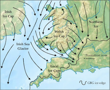
Next, I have no problems with what the authors say about ice flow directions and the likelihood of glacial erratic transport.  It is indeed very difficult to conceive of ice flow conditions that might have facilitated the glacial transport of a large sandstone erratic from the ORS Orcadian Basin all the way to Salisbury Plain, via either a west coast or east coast route.  As far as we know, the ice flow in the last (Devensian) Glaciation was from SE towards NW across Orkney, as described earlier on this blog. 

https://brian-mountainman.blogspot.com/search?q=+Orkney+ice+flow


Source:  Adrian Hall et al, 2016

This means that the erratics from Orkney would have been transported out into the North Atlantic, and there is no obvious mechanism for them to have been picked up by southward-flowing ice.  That having been said, we are still in the dark about what happened in earlier glaciations, including the Anglian.  It is not beyond the bounds of possibility that a large erratic of ORS sandstone from the Orcadian Basin could have been moved multiple times, during assorted glacial phases, before being transported south by the Irish Sea Ice Stream that originated off the west coast of Scotland.  The abundant erratics of Ailsa Craig microgranite (from the Firth of Clyde)  in West Wales confirm both the ice source and the direction of flow. 

Next, what ids the quality of the geology in this paper?   I await further specialist advice, but I am not very impressed.  

1.  The large and very elaborate piece of research may all be a complete waste of time because we do not know whether the two samples deemed to have come from the Altar Stone actually did so.  They are fragments sampled by Bevins, Ixer et al, but they came out of an old box -- like many of their other samples -- and they may not have anything to do with the Altar Stone apart from having been found quite close to it.

2.  That having been said, what of the other samples?  There is nothing in the article about sampling protocols, but the ones deemed to be representative of the ORS sandstones of the Orcadian Basin have come from Spittal on Caithness and Cruaday on Orkney. 


Cruaday Quarry on Orkney, just down the hill from Vestra Fiold, flagged up enthusiastically by archaeologists as the source for the Stones of Stenness and the Ring of Brodgar.

 You can see where this is leading, can't you?

https://brian-mountainman.blogspot.com/2023/04/did-vestra-fiold-quarry-provide.html

https://brian-mountainman.blogspot.com/2014/01/ring-of-brodgar-and-its-quarry.html

https://brian-mountainman.blogspot.com/2014/02/ring-of-brodgar-again.html

https://brian-mountainman.blogspot.com/2011/11/beware-quarry-hunter-on-prowl.html 

It is clear to me that the authors of the current paper have taken a piece of sandstone from one of the massive grey-green sandstone beds in the hope of demonstrating that the Altar Stone came from Vestra Fiold and that it is a first cousin of the standing stones at Stenness and Brodgar.  The local geology of the Stromness Sandstones according to Wikipedia:

Most of the Old Red Sandstone of Orkney is of Middle Devonian age. The lower part of the sequence, mostly Eifelian in age, is dominated by lacustrine beds of the lower and upper Stromness Flagstones that were deposited in Lake Orcadie. The two flagstones sequences are divided by the Sandwick fish bed, equivalent to the Achanarras formation of Caithness, representing an unusually persistent, deep and widespread lake that filled much of the Orcadian Basin. The sequence continues with the Rousay flagstones deposited in a similar lacustrine environment. The flagstones show a marked cyclicity in their sedimentation, with 86 such cycles being counted for the whole sequence. These are interpreted as representing regular climatically driven changes in lake level caused by Milankovitch cyclicity

The Eday Group overlies the Rousay Flagstones and represents a change to dominantly fluvial/aeolian deposition with only occasional lacustrine intervals. The Eday Group consists of three sandstone units, the lower, middle and upper Eday Sandstones separated by the Eday Flagstones and Eday Marl respectively. The Eday Marl consists mainly of red and green mudstones and siltstones and is thought to have been deposited in a river floodplain environment. Locally pseudomorphs of halite have been found and rarely marine microfossils (scolecodonts) indicating that the basin was affected by occasional marine incursions at this time. 

I think we can also assume that the geologists have failed to find any sort of match between the Altar Stone samples (supposed) and the rocks of Vestra Fiold and Cruaday.  If they had found a match, the banner headlines would have been even larger than they already are!

To be continued.  More on the technical stuff as soon as we can manage........


====================


ABSTRACT

Understanding the provenance of megaliths used in the Neolithic stone circle at

Stonehenge, southern England, gives insight into the culture and connectivity of

prehistoric Britain. The source of the Altar Stone, the central recumbent sandstone

megalith, has remained unknown, with recent work discounting an Anglo-Welsh

Basin origin.  Here we present the age and chemistry of detrital zircon, apatite and

rutile grains from within fragments of the Altar Stone. The detrital zircon load largely

comprises Mesoproterozoic and Archaean sources, whereas rutile and apatite are

dominated by a mid-Ordovician source. The ages of these grains indicate derivation

from an ultimate Laurentian crystalline source region that was overprinted by

Grampian (around 460 million years ago) magmatism. Detrital age comparisons

to sedimentary packages throughout Britain and Ireland reveal a remarkable

similarity to the Old Red Sandstone of the Orcadian Basin in northeast Scotland.

Such a provenance implies that the Altar Stone, a 6 tonne shaped block, was sourced

at least 750 km from its current location. The difficulty of long-distance overland

transport of such massive cargo from Scotland, navigating topographic barriers,

suggests that it was transported by sea. Such routing demonstrates a high level of

societal organization with intra-Britain transport during the Neolithic period.