Coherent Devensian till on the clifftop (alt c 55m) near Short Point, on the western flank of the Dale Peninsula. This till, coloured by the incorporation of ORS materials, is very similar to the till at Ballum's Bay on Caldey Island and to other tills on the ORS coast of South Pembrokeshire
It's becoming clearer that the Dale Peninsula, at the entrance of Milford Haven, was overwhelmed by glacier ice during the Devensian glaciation. This, of course, makes perfect sense, since there are glacial deposits which must be Devensian in age about 4 km to the east, on the other side of the Haven mouth.
These are my earlier notes on Westdale:
https://brian-mountainman.blogspot.com/2014/03/westdale-bay-close-to-devensian-ice-edge.html
https://brian-mountainman.blogspot.com/2017/07/westdale-bay-and-meltwater-channel.html
and I have attempted to look at the regional context here:
https://brian-mountainman.blogspot.com/2017/03/the-south-pembrokeshire-lgm-again.html
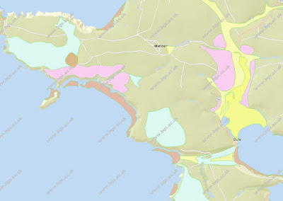
The above image, from the BGS online viewer, confirms the presence of both surface till (blue) and fluvio-glacial sands and gravels (pink) in the area. The map isn't all that accurate, and the till is certainly more extensive than shown. The sands and gravels are in two main patches, one to the north of Marloes Beach, and the other around Mullock Bridge, which I described in a paper in 1972:
If the terrace of fluvioglacial materials is indeed a kame terrace, as is suggested by some of the sedimentary structures in the sands and gravels, it must have had ice on its eastern flank. Ice must have filled the Gann Valley, and maybe it extended as far eastwards as St Ishmaels. More work is needed to define the limit.
On a visit this morning to the western side of the Dale Peninsula I was able to examine the clifftops between the old HMS Harrier installation and Westdale Bay. Coherent reddish till is found on the clifftops in many locations -- and it looks as if it is in situ -- undisturbed and not redistributed. These are typical exposures:
These till exposures (mostly less than 1 m thick) are resting directly on brecciated ORS bedrock, and they are overlain by up to 20 cm of loess or sandrock, with a very thin modern soil. The lack of brecciated slope deposits either below or above the till is explained by the lack of slopes down which materials might have been mobilised. The till contains erratics of sandstone, quartzite, dolerite and bluish volcanic ash, possibly from Skomer Island. The largest clifftop erratic seen in this area was a dolerite block approx 1.5 m in diameter.
The maximum thickness of till seen along this coast is about 4m, and it is assumed that it is the same till as that mapped as a surface spread by the BGS officers.
I'm also intrigued by the apparent meltwater channels in the Peninsula. The deep valley that runs from Westdale through to Dale Village carries just a small "misfit" stream today, and it runs eastwards, not westwards. It must have carried a large volume of glacial meltwater at one time -- maybe at the time of Devensian ice wastage. There is another blind valley on its southern flank, about 500m long, running south - north. There is another interesting valley running towards Castlebeach Bay, on the eastern side of the Dale Peninsula. And the strangest valley of all is at The Hookses, north of Westdale Bay -- it shelters a substantial house and several outbuildings today, and it was modified when the runways of Dale Aerodrome were built during WW2 -- but it bears comparison with the Valley of the Rocks in Devon. It might have carried south-flowing meltwater from melting ice on the plateau around Marloes.
The outlet of The Hookses meltwater channel.


No comments:
Post a Comment