THE BOOK
Some of the ideas discussed in this blog are published in my new book called "The Stonehenge Bluestones" -- available by post and through good bookshops everywhere. Bad bookshops might not have it....
To order, click
HERE

Wednesday, 13 November 2024

The Berry House boulder, north of Shebbear


From Google streetview -- this is a hefty boulder, on the roadside verge at the entrance to Berry House

More on the Shebbear erratic boulder


Found in the NDAS Newsletter, Autumn 2017
http://www.ndas.org.uk/NDAS%20Newsletter%20Autumn%202017.pdf


This is very interesting. More on Shebbear........... John Bradbeer is quite certain that the Shebbear and Berry House stones are both sarsens, related to those on Salisbury Plain and other parts of southern England. He suggests that the two stones have come from destroyed Tertiary deposits, and have been "let down" onto the present land surface.  Until further evidence is forthcoming, this sounds like a reasonable explanation.  More research please, from those who live over that way......

The Devil’s Stone at Shebbear: A Landscape Enigma

John Bradbeer

Members will probably be aware of the Devil’s Stone, which lies at the west end of the square, just outside the churchyard in Shebbear. It represents an enigma taking in archaeology, geology and geomorphology (the study of landforms). The stone itself is at the centre of much folklore, culminating in a ceremony every 5th November, when the stone is turned. This is to flush the Devil out from his
possible hiding place under the stone and failure to do so puts next year’s crops in jeopardy. Another element to the story is that the Devil was escaping from Northlew, where he was in danger of catching his death of cold and to hasten his progress, he dropped the stone in Shebbear. We can probably explain the November timing of the turning of the stone with reference to the Celtic year in which the
first of November, Samhain (pronounced sawin) marks the start of winter. The shift to 5th November almost certainly came about after the Gunpowder Plot of 1605.

The stone itself is around 500 to 700 kilograms in weight and sub-angular rather than round in shape. It is described geologically as a conglomerate orthoquartzite, and to the untrained eye, the shiny quartz grains resemble the quartz crystals in granite. It is in fact a sedimentary rock and current thinking suggests that it is Tertiary in age and thus comparable with the sarsen stones (or ‘grey wethers’) that are found on Salisbury Plain and which, of course, were famously used at Avebury and Stonehenge. It is generally accepted that sea levels were very much higher in the Tertiary period, roughly 5 to 50 million years ago, and many of the succession of erosion surfaces (from c 50 to c 350 metres OD) that give such flat skylines across much of the county were cut at this time. Most of the presumed Tertiary cover of South West England has long since been eroded away, but Tertiary deposits are preserved on the top of Haldon Hill, south west of Exeter and in the down-faulted Bovey Basin in South Devon and here in North Devon in the Petrockstow Basin and the off- shore Stanley Basin near Lundy. Orleigh in Buckland Brewer has a flint gravel deposit presumed to be of Tertiary age and derived from a former cover of chalk. The Tithe Apportionment of 1841 records some fields as ‘Flint Hill’. So geologists can offer a plausible origin for the Devil’s Stone, but what happened to the other survivors from this former Tertiary cover remains an enigma.

In central southern England, besides the sarsens used at sites like Avebury and Stonehenge and incorporated in some of the barrows, there are clusters such as those found in a dry valley on
Fyfield Down, just north of Pewsey in Wiltshire. Geomorphologists can explain such a cluster by reference to solifluction flow during the very cold periods in the Quaternary when southern England was effectively tundra, lying just to the south of the great ice sheets and the summer thaw delivered sufficient water to move soil and sarsens stones down slope. The river terrace gravels along the Solent also contain many smaller fragments of sarsen stone, brought down by the rivers that drain much of Salisbury Plain. But where are the other sarsen stones from North Devon? On Salisbury Plain it is plausible to speculate that early humans found and moved many of the suitably large stones to incorporate in monuments, but in North Devon, there are no megaliths formed of sarsens. North
Devon’s river gravel terraces, of which there may be at least four or five, have never been exploited so no sarsens have been exposed from these. Perhaps there never were as many sarsens here and most were quite small and thus readily transported or fragmented into yet smaller pieces.


The Devil’s stone at Shebbear 


However, the enigma has another twist. For about 750 metres from the Devil’s Stone is another sarsen, rather larger at an estimated 1,500 to 2,000 kilograms, now on the verge in front of Berry House and one that looks far more like potential megalith material in shape. That two such stones should survive so close to each other yet no others appear to have survived anywhere in North Devon requires explanation. Clearly human agency has to be invoked in the survival and folklore attached, especially to the Devil’s Stone, but archaeology and geology have no real explanation as to why there should be just these two sarsens and no others known in North Devon.  (Note from BJ:  could these stones have been carried from a source area near the coast, by an ice tongue pressing inland from the Fremington - Barnstaple area?)


The Berry House erratic, more than twice the size of the Shebbear stone, and weighing in 
at almost 2 tonnes.........


Monday, 11 November 2024

A very silly rant from the pet rock boys


Well, this is rather entertaining -- and more than a little pathetic.  Pearce, Bevins, Ixer and Scourse have put together a furious synthetic rant designed to question my competence and destroy my credibility.  It's just been published in Quaternary Newsletter:

Pearce, N., Bevins, R., Ixer, R. and Scourse, J.  2024.  Comment on "An igneous erratic at Limeslade, Gower, and the Glaciation of the Bristol Channel" by Brian John.  Quaternary Newsletter 163, pp 15 - 20.

Also very entertaining is Tim Daw's instant report on his blog.  Ah, the faithful retainer can always be relied on to help his muckers when they are in a spot of bother.  His report, with carefully selected quotes, is flagged up as "the professional response" to my Limeslade article !!  It's quite touching to see such blind loyalty from an amateur.

Maybe you shouldn't be too surprised.  I'm not surprised at all.........

As readers of this blog will know, my short article published earlier this year presented some preliminary information on the Limeslade boulder, including pXRF data kindly provided by the late Prof Tim Darvill, and assessed its importance in the debate about the glaciation of the Bristol Channel.  In the article I recognised the shortcomings of just three readings from one sample from the boulder, and looked forward to seeing more intensive and detailed analyses of other samples from the boulder by other researchers.  I said: "There is inadequate data for the creation of scatter diagrams or bivariate graphs involving the Limeslade boulder ppm readings. So it is not possible at present to say that the pXRF readings occupy a different visualised “compositional space” for trace elements than the readings for the Preseli tors."

Not everybody has access to research funds and top class laboratory facilities, and when Prof Tim Darvill and Dr Steve Parry offered to help in obtaining pXRF readings, I was grateful for their involvement. 

Instead of accepting this preliminary work with good grace as a starting point for future research, Pearce et al  have subjected it to detailed -- and it has to be said, obsessively aggressive and petulant -- scrutiny, while in the process questioning the competence of other geologists whose notes I reproduced word for word.  I am at a loss as to why these four academics have allowed themselves to be sucked into this absurd spat.  They cannot possibly come out of it with any credit.

In the second part of their article Pearce et al accuse me of  "a polemic against the advocates of human transport (e.g. Parker Pearson et al., 2021)".  I strongly refute that.  My assessment of the human transport thesis (on pp 10 and 11) is carefully phrased, and constitutes a straightforward review of the narrative developed over the last decade by Parker Pearson, Ixer, Bevins and others.  Indeed, my comments are supported by the dramatic retreats made by these authors from the spectacular claims they were making just a few years ago.  These retreats (for example on Waun Mawn) are well known to all who read the literature.

The latter part of the Pearce et al article relates to the glaciation / sea ice transport issue, and I take issue with almost everything that they say.  I will revisit that in a later post.  I will not accept snide comments from people who have apparently never done any field work in West Wales relating to the Quaternary stratigraphic sequence.  Nor will I accept a "holier than thou" attitude from geologists who have, over the last decade, refused to cite "inconvenient literature" or to accept that any of their ideas are questioned or disputed by anybody else.

As for their parting shot:  "This article merely represents a disingenuous cover to justify a rehearsal
of the now well-worn and increasingly tedious debate concerning transport of the Stonehenge bluestones."  That really is beneath contempt.  The article I published was fashioned in part by the constructive comments of the journal editor and referees. The "tedious debate" to which Pearce et al  refer has been fuelled and perpetrated by an endless stream of journal and popular science magazine articles which they themselves have written, many of them recycling the same basic data, designed to promote the strange fantasy that the Preseli bluestones at Stonehenge were targetted, quarried and transported by our Neolithic ancestors.

Watch this space........

Details:

Brian John, 2024. An Igneous Erratic at Limeslade, Gower & the Glaciation of the Bristol Channel. Quaternary Newsletter 162, June 2024. pp 4 - 14.

The article is freely accessible, and can be downloaded here:

https://www.qra.org.uk/quaternary-newsletter/quaternary-newsletter-current/

It is also on Researchgate, and can be accessed here:

https://www.researchgate.net/publication/381775577_Quaternary_Newsletter_Article_AN_IGNEOUS_ERRATIC_AT_LIMESLADE_GOWER_AND_THE_GLACIATION_OF_THE_BRISTOL_CHANNEL

Saturday, 9 November 2024

The Shebbear erratic


https://www.facebook.com/groups/2003881253140331/posts/turning-of-the-devils-stone-shebbear-2024/2559590600902724/

Thanks to Tony for drawing attention to this.  The famous Shebbear erratic lies at an altitude of c 146m and is c 15 km from the Devon coast.  It is likely to have been carried into position by an ice stream travelling from the N or NW.  Over most of its surface it appears to be deeply weathered and abraded, but some breakages are apparent, and these might be of different ages.  They look like glacial facets, since the fracture scars are themselves abraded.  Some damage might of course have been done down through the centuries because of the village obsession of tipping it over every year on November 5th............

There is no reason at all to think that the Devils Stone might have been collected up somewhere on the coast and carried into its present position by the villagers or their ancestors.......  However, there is one tradition that the stone came from Henscott, near Bradford,  to the SW of Shebbear and to the west of the River Torridge.  LIDAR images show that there were a number of small quarries in the area, no doubt used for local building purposes.

At both Shebbear and Henscott the local rocks are fine grained sedimentary rocks of Carboniferous age -- mostly mudstones, siltstones and sandstones.

There are still people who argue that the large glacial erratics in Devon and Cornwall are concentrated in the intertidal zone along the present coast.   This is just not true, as I have pointed out on many occasions.  On at least one occasion there were Quaternary ice caps on Dartmoor and Exmoor, and we know from other evidence that glacier ice from the Irish Sea Ice Stream pressed inland from the Bristol Channel;  but we still do not know where the boundary between local ice and "invasive ice" might have been.


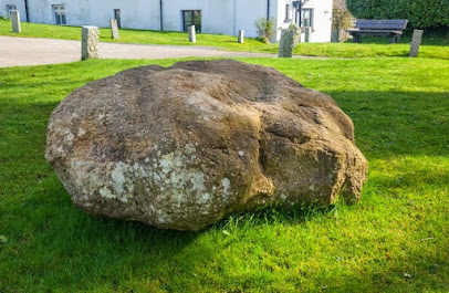


The stone is said not to be local, and it looks to me as if it might be a coarse conglomerate or igneous rock.  Some say it is a gravelly sarsen stone or an "arenaceous conglomerate".  Others report it as being made of "quartz" and others claim it is made of pinkish granite.  It has dimensions c 6 ft x 4 ft and is reputed to weigh about a tonne.  It was clearly once a great deal bigger than it is today-- the facets are substantial, both on the top and bottom of the boulder.


The turning of the stone in 1946

In one of the reports on the stone, it says that there are other similar erratics in the vicinity.  One stone is mentioned c 750m to the north of the village, where the surface altitude is 173m.   I am intrigued............


Sunday, 3 November 2024

25th Anniversary -- Kindle celebration


This has nothing to do with Stonehenge or the Ice Age, but one of the joys of being a blogger is that one can very occasionally post something quite irrelevant, in the hope that some people out there might be interested.  Anyway, forgive me dear reader -- but here's the deal........

-----------------------

For five days, starting on Monday 4th November, we will have a free "anniversary" promotion on the Amazon web site, with the Kindle versions of the first three books in the saga.  You can download the digital or "electronic" versions of the three novels completely free of change.

https://www.amazon.co.uk/dp/B074CFGRJ6?binding=kindle_edition&qid=1730659108&sr=1-1&ref=dbs_dp_rwt_sb_pc_tkin

Just click on the Kindle edition of each book to order your free download.

Enjoy!!

Here's the story:

In 1999 my wife and I flew to Gran Canaria on holiday, and en route I was struck down by aerotoxic syndrome. I felt sick before we landed, but then I experienced classic flu-like symptoms. I went straight to bed when we arrived at the apartment, and spent the night wide awake, feeling very ill indeed. One hears about "a fevered imagination" and now I know what it means. Anyway, a story came into my head - of a feisty woman called Martha Morgan. It was "narrated" -- I can still recall the female voice. Dates, places, characters, and a storyline covering the greater part of her life from 1796 to 1855. Individual episodes came into my head, and I even "heard" key conversations.

In the morning, not having slept a wink, I felt better, but the story was fixed firmly inside my head. I told my wife about this strange experience, and she said “Well then, you’d better start writing!” So I did..... and I knew that the story had to be told in Martha's own words, with immediacy, through diary entries.

Twenty-one years later, I still do not know what to make of that episode. l think that the story was “given” to me, and that in order to keep faith I had -- in the beginning -- to try and put into words the emotions and experiences of a pregnant, suicidal 18-year-old female who lived more than 200 years ago.

The narrative extended, eventually, across eight novels; and I can honestly say that the only one of those that involved the "invention"of characters and narrative was "Guardian Angel". The reasons for that will be obvious to the loyal readers of the Saga.

Wednesday, 30 October 2024

Carningli summit


This is another great image from the Preseli360 drone camera, showing just how rugged the summit is when seen from the S or SW.  Jagged rock faces and scree slopes are normally associated with shaded of lee side slopes facing N or NE, but here they face south and south-east.  I have pondered long and hard on the explanation for this -- and am convinced that the NW flank of the mountain was "cleaned up" by the overriding ice of the Irish Sea Ice Stream coming in from Cardigan Bay and travelling NW towards SE.  The face we are looking at in the photo is the plucked face with features we often associate with the down-glacier sides of roches moutonnees.  I think there may well have been a wind-scoop feature here as well, maybe lasting for thousands of years and allowing frost shattering and scree accumulation to proceed more or less unhindered.

And another from Hugh.........


Monday, 28 October 2024

Glama Plateau and Dynjandifoss


I rediscovered this excellent photo on a Facebook geomorphology page, showing the Dynjandifoss waterfall (the biggest waterfall in NW Iceland) on the edge of the Glama Plateau.   We did a helicopter reconnaissance and wandered about up there back in the 1970's -- it was fascinating because it was the location of a small ice cap that has now completely disappeared.

Put "Glama" into the search box and you will find some of my other posts.  

There are more excellent photos of this area on Gareth McCormack's web site:


Close-up of the waterfall.  Photo:  Gareth McCormack