THE BOOK
Some of the ideas discussed in this blog are published in my new book called "The Stonehenge Bluestones" -- available by post and through good bookshops everywhere. Bad bookshops might not have it....
To order, click
HERE

Thursday, 1 February 2024

Penfro Till Formation and the geological time scale

For the greater part of a decade I have been trying to get the "Penfro Till" entry in the BGS Lexicon changed.  After all my representations  to the powers that be, urging them to forget about West Angle and Llandre as "stratotypes", they still haven't done a proper investigation or altered the record.

As for Pencoed as the "type section", that needs examining too, since there is now a distinct possibility that at least part of the much-quoted Quaternary sequence there is Late Devensian in age.

Ah, they probably say over at BGS HQ, the only time scale that matters is the geological one........... and in due course, after careful consideration, something on the record might be corrected.   Maybe.  With a bit of luck......


The "special" Rhosyfelin rhyolite -- a triumph of marketing over science?


Part of an erratic boulder found in a wall on the Parrog, Newport.  Not "rhyolite with fabric" but "rhyolite with at least six fabrics"............  Origin unknown......

It's a funny old life. There we were a few days ago, taking a stroll down on the Parrog in Newport, when I noticed that one of the glacial erratics in a wall that I have walked past hundreds of times before appeared to have a patch of foliated rhyolite on it. As I will no doubt be reminded by certain geologists who have axes to grind, I know nothing at all about geology, but I do know a similarity when I see one --and I think I know a rhyolite from a gneiss. 

I was a bit suspicious at first, since this rock looks similar in some ways to the "laminated mudstone" in the N corner of Traeth Mawr, near the waterfall.  But on closer examination that rock is seen to have a uniform grey-blue colour and concentrations of whitish sand grains in very thin layers.  It belongs to the Ordovician Dinas Island Formation, and is described by BGS as a "laminated hemipelagic mudstone with subordinate turbidite sandstones".........  so it's a deep-water sedimentary rock similar to the rocks exposed along much of the coast between Newport and Fishguard.

Back to the boulder.  It's  made of a much harder rock, with richer colours, immense internal fabric variations and a typical rhyolite sheen. I await more specialist geological advice, but I do not think the boulder has a local origin within Newport Bay. But just inland of Newport there is a great expanse of the tuffs and lavas of the Fishguard Volcanic Series, and within this band there are scores of outcrops of rhyolite.  This boulder could have come from any one of these outcrops.


Extract from the BGS Geology Viewer, annotated.  There are frequent rhyolite outcrops within the marked FVG area.

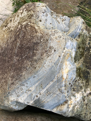
Back to the boulder:

 
Very colourful banded rhyolite exposed on the side of the Parrog boulder


Foliated rhyolite (?) on the boulder, very similar in appearance to some of the foliated rhyolite "with Jovian fabric" seen at Rhosyfelin.  Click to enlarge.

It's interesting to see how the terms "rhyolite with fabric" and "Jovian fabric" have been used in the marketing of the "monolith quarry" at Rhosyfelin.  Over and again the terms are used (mostly by archaeologists) with a pretence that they are scientific or diagnostic terms that are crucial in the arguments about the precise provenancing of Stonehenge rhyolite fragments to Rhosyfelin and to nowhere else.  These extracts are typical:

From: Parker Pearson et al (2015) Craig Rhos-y-felin: a Welsh bluestone megalith quarry for Stonehenge — p 1333

More than 1200 chippings from the 2008 Stonehenge Riverside Project (Parker Pearson 2012) and the SPACES project (Darvill & Wainwright 2009), and from excavations at Stonehenge in 1980 (Pitts 1982), have been characterised as ‘rhyolite with fabric’ (Ixer & Bevins 2010; Bevins et al. 2011). Most of these have been found in the centre of Stonehenge, but they also occur in its environs, almost as extensively as the spotted dolerite chippings. Six ‘rhyolite with fabric’ chippings were recovered from Aubrey Hole 7 in 2008. Of the 27 from the Stonehenge Avenue, one was found in a layer beneath the Avenue’s banks, and was thus deposited before 2480–2280 cal BC (see Darvill et al. 2012), indicating that ‘rhyolite with fabric’ was present at Stonehenge before the Early Bronze Age.  The fabric of this particular type of rhyolite is macroscopically typically planar, with a prominent foliation developed on the millimetre scale. In thin section, the foliation is seen to be slightly lensoidal, and contains flattened, ovoid lithic clasts (2–5cm) of microtonalite. Locally, the fabric is extremely well developed and described as ‘Jovian’ because it resembles the swirling weather patterns on Jupiter (Ixer & Bevins 2011). The main rock is commonly traversed by thin quartz veins that are tightly folded, with their folds being axial planar to the foliation, suggesting that the rock fabric is most probably not a primary texture but a later (tectonic) flattening fabric.  A strong petrographic match for these rhyolite fragments has been found with outcrops in the Pont Saeson area just north of Mynydd Preseli, specifically the outcrop of Craig Rhos-y-felin, belonging to the Fishguard Volcanic Group, of Ordovician age (Ixer & Bevins 2010; Bevins et al. 2011). This match is closest for samples from the north end of the outcrop’s near-vertical western edge ............

From Parker Pearson et al, 2022:

It is likely that just one bluestone pillar was extracted from the outcrop at Craig Rhos-y-felin (Fig. 4). This striking outcrop is situated in the bottom of a steep-sided valley along which flows a stream that rises close to Carn Goedog and forms a tributary of the River Nevern (Parker Pearson et al., 2015; 2019). Initial geological sampling at 19 locations around this outcrop through the stratigraphy of the rhyolitic body revealed just one location, close to the northern tip of the outcrop, where the ‘Jovian’ micro-structure of spherical to lensoidal features (named after the famous ‘spots’ in Jupiter’s atmosphere) within the rhyolite matches the fabric identified within some of the flakes from Stonehenge and its environs (Ixer and Bevins, 2011).

But what do these terms actually mean? Are they of any use in demonstrating a really precise match between samples from widely different locations? 

Rhyolite with Fabric

The term "rhyolite with fabric" is a very strange one, since all rocks have a fabric. According to Wikipedia, "fabric" describes the spatial and geometric configuration of all the elements that make it up. There are two principal varieties of oriented fabrics: primary (or depositional) and secondary (or deformational). So there is no such thing as "rhyolite without fabric", and on that basis the term "rhyolite with fabric" can be dismissed as meaningless. As for the "Jovian fabric" in Rhyolite Group C which is claimed to be so unique that certain Stonehenge fragments can be provenanced to "within a few square metres" at Rhosyfelin, I have argued over and again that this is a claim unsupported by the evidence presented.  

https://brian-mountainman.blogspot.com/2014/04/on-significance-of-rhosyfelin-locality-8.html

https://brian-mountainman.blogspot.com/2015/09/rhosyfelin-some-geological-questions.html

https://brian-mountainman.blogspot.com/2015/09/rhosyfelin-and-spot-provenancing.html

https://brian-mountainman.blogspot.com/2016/08/rhosyfelin-spot-provenancing-and-few.html

The published thin sections from the Stonehenge samples and those collected from Rhosyfelin and the Pont Saeson area have produced no perfect matches.  Ixer and Bevins have assured us in various publications that "rhyolite with fabric" (or "Jovian fabric") as seen in the Pont Saeson area does not occur anywhere else in North Pembrokeshire, in any of the other abundant rhyolite outcrops. They tell us that, but they have never actually demonstrated it through the presentation of evidence in an accessible journal.  In several papers they discuss the geochemistry and petrography of some of the rhyolite outcrops of North Pembrokeshire, and find that they do not match any of the fragments collected from the Stonehenge debitage and referred to as Rhyolite Group C.  

Quote from p 22 of the 2011 paper:  "In the Pont Saeson area the Fishguard Volcanic Group comprises a strongly foliated to foliated and lensoidal rhyolitic rock the like of which is not seen elsewhere in the outcrop of the group across the 32 km of strike section from Pen Caer in the west to Crymych in the east."
    
Quote from p 24:  "Although there are subtle but distinct differences between different rhyolitic outcrops at Pont Saeson, including those on Craig Rhos-y-felin, they share a distinctive petrography that is unrecognised from elsewhere in the Fishguard Volcanic Group."

About 20 samples are analysed and discussed (including those collected for the OU research published in 1991), but it is obvious from any examination of the published thin sections that there are no exact matches, and we are not shown any slides of samples of foliated rhyolite from other outcrops across North Pembrokeshire.  One of the ancient rules of scientific writing (and writing TV drama, come to think of it) is "show, don't tell....."

Williams-Thorpe and Thorpe (1991) demonstrated many years ago that on geochemical grounds the rhyolite debris at Stonehenge could be identified as having come from multiple North Pembrokeshire sources. They favoured Carn Alw as the source of four monoliths and some Stonehenge fragments, but this was later disputed by Bevins and Ixer.  

If one reads the key research articles by Bevins and Ixer (2010 and 2011), one sees that neither the "rhyolite with fabric" nor "Jovian" labels are of very great importance. The labels are probably used in order to appeal to non-geologists.  In fairness to them, they explain that detailed petrology and geochemistry are far more important in differentiating Group C rhyolites from the groups which used to be called A, B, D, E and F. But they don't make it easy for the rest of us.   Now Group A samples are called andesites and samples from groups B, D and G are referred to as dacites.  Confused?  You are not alone.  We must not forget that no known monolith at Stonehenge provides a match for any of the samples taken from the Pont Saeson area.  The only reason for the emphasis on Rhosyfelin is that MPP, Ixer, Bevins et al think they they have found a quarry there.  Sources still have not been found for all the other rhyolite fragments and rhyolite monoliths at Stonehenge.  They may have come from North Pembrokeshire, and maybe not.

To make life even more confusing, in a paper by Ixer et al (2023) on the Andesite Group A fragments they accept that fragments classified within some of the other volcanic groups might have come from "the same lithic" -- in other words, from the same boulder or monolith.  This is an admission that there is huge variation in fabrics and geochemistry across the rhyolite fragments found at Stonehenge and across the rhyolite outcrops of North Pembrokeshire -- and the rhyolite boulder featured at the head of this post is a classic example of that.  


Jovian Fabric

The use of the term "Jovian fabric" as a diagnostic feature is similarly dodgy.  When I asked a European petrologist about the lensoidal or "jovian structure" of some of the rhyolites at Rhosyfelin, and showed him some of the images from Ixer and Bevins, he replied:  ".... they are not rare structures, in fact, they are quite common in rhyolites. In this case they are due to magmatic flow.  Rhyolites are rocks deriving from very viscous lavas and form flow structures like this! Sometimes the cause is high temperature deformation during metamorphism."


Patterns in the atmosphere of the planet Jupiter -- the inspiration for the use of the term "Jovian" by Ixer and Bevins.

Also found on the web -- highly deformed mylonite from the western Alps:


Jovian textures -- courtesy Alessandro Da Mommio


Augen texture in gneiss (Photo: Marli Millar)


One of the samples showing a "Jovian fabric" from Rhosyfelin, published by Ixer and Bevins.  All of the published thin sections are different, pointing to a range of textural characteristics and probably a range of provenances.

===============================

Ixer and Bevins may be right in their claim that certain fragments at Stonehenge have come from the Pont Saeson area -- and that would be fine, as far as I am concerned. But the find of this interesting boulder down on The Parrog reminds us that there are other rhyolites in North Pembrokeshire that are foliated and light blue in colour, with a wide range of internal characteristics, and I would like to see some evidence that these outcrops have NOT contributed any of the rhyolitic debitage that has ended up at Stonehenge.

I don't think that any of the rhyolite outcrops of North Pembrokeshire (such as Carn Alw, Carn Gwiber, Carn Cwn, Foel Drygarn, Carn Afr and Carn Fron) can be excluded as possible sources for the rhyolite fragments found at Stonehenge unless it can be demonstrated that the outcrop samples analysed thus far from such places really are typical or characteristic of the outcrops as a whole.  The old problems of sampling density and sampling bias are there, as they always were.   But where extravagant claims are made about provenancing that is "accurate to within a few square metres", those claims need to be backed up by pretty extraordinary and detailed evidence.  And as I have said many times before, the quality of the "evidence" presented thus far by Ixer, Bevins et al is inadequate.

Whatever the truth of the matter, I think we should accept that the terms "rhyolite with fabric" and "Jovian fabric" are useless and even misleading.  They do not point to unique characteristics, and the terms are of no use whatsoever in helping us to understand where some of the fragments in the Stonehenge debitage might have come from.


The Stonehenge sarsens were from multiple sources -- are we surprised?

Source:  Ciborowski et al, 2024

Thanks to Peter for bringing this new paper to my attention.

Well well -- the sarsen story at Stonehenge gets more and more interesting.  As readers of this blog will recall, we had a bit of a spat with David Nash about the reliability of the evidence pointing to West Woods as the prime source of Stonehenge sarsen monoliths.  Shall we say that on the evidence as it was presented (in 2020), I was not entirely convinced.........

https://brian-mountainman.blogspot.com/2020/07/sarsen-sources-and-instrumental.html

Then along came our old friends Ixer and Bevins in 2021 to make the point that too much certainty in pXRF work is not a good idea, and that results can be heavily influenced by the frequency and locations 
of sampling in the field.  There are other variables that might also skew results, as all who use the technique readily admit.  I & B suggested that the Stonehenge sarsens (and in particular the smaller pieces used as packing stones, hammer stones etc) might well have come from multiple sources.  That sounded perfectly reasonable to me, and their argument was convincing.


Now this latter point is reinforced by a new study from Jake Ciborowski and David Nash, with inputs from some of the key Stonehenge players including Tim Darvill and Mike Parker Pearson, presumably related to the use of data from their Stonehenge digs.

So what does the new paper say? It's long and very complex, and (not surprisingly) there is no move away from the view that almost all of the sarsen monoliths to be found at Stonehenge were carried by Neolithic tribesmen from West Woods. The authors continue to maintain that the pXRF evidence presented cannot be interpreted any other way. 

 In this paper they move on to the "sarsen debitage" and having examined over 1,000 fragments using pXRF methods they decide that "none are debitage produced during the dressing of stone 58 or its 49 chemical equivalents at the monument".  They spend a lot of time in the paper testing for variations in the examined fragments, due to surface weathering and other factors, but conclude that the results are reliable and representative.  They suggest that the samples fall into three "families" with similar geochemical characteristics.  This is where it gets interesting.  They take 54 excavated sarsen fragments and compare them with the data from 20 different sarsen areas in southern Britain, and suggest that only 15 have matches in specific localities -- 11 from the Marlborough Downs, 3 from Bramdean in Hampshire, and 1 from Stoney Wish in East Sussex.  This means that no matches were found for 39 of the fragments, and it means that extremely ambitious (and maybe irresponsible) assumptions are made about the other fragments and their sources on the basis of extremely thin evidence.  For example, what evidence is there that the "geochemical signature" assumed for Stoney Wish is not also found in many other sites much closer to Stonehenge, which do not happen to have been analysed?  That signature may also exist, undiscovered, at sites that HAVE been examined and sampled.  The authors admit that they have a credibility problem when they say, later in their analysis: "......the West Woods outcrop has a compositional range that extends beyond the three samples used to first characterise it".   Hmmmmm.   Let's just say that I am deeply sceptical about anything of significance having been found here........I need MUCH more evidence before I can take any of this seriously.

Quote, concerning the one fragment supposed to have come from 123 km away, in the deep south:  
The presence of sarsen fragments with a geochemical signature exotic to the Marlborough Downs is, however, intriguing. Bramdean lies 51 km southeast of Stonehenge, while Stoney Wish is even further to the southeast at 123 km distant. Given the known extent and direction of movement of Quaternary ice sheets (sic), it is impossible that exotic sarsen material was brought to Salisbury Plain from Hampshire and Sussex via glacial transport (e.g. Lee et al., 2011; White et al., 2017; Scourse et al., 2018; Clark et al., 2022). Instead, the only viable explanation is that it was transported there by humans.   

That is a very big point to make, on the basis of one small and rather dubious fragment of sarsen stone.....

There are some other interesting points in the discussion arising from the analyses of the 4 "rogue"samples.  The authors discuss the use of materials from multiple sources in other megalithic monuments across the British Isles, referring to monoliths, hammer stones and packing stones,  and fragments found in the debitage.  But so obsessed are they with their hypothesis of human transport that not once do they refer to glacial erratics or glaciation.  They prefer rather convoluted explanations of material re-use, recycling and redistribution, with speculative motives added for good measure. They cite the work of Thorpe et al in 1991, but cannot bring themselves even to mention their central point -- namely that the use of materials from multiple sources in a monument is in itself a powerful pointer to the involvement of glacier ice.

I am amazed that this defect was not picked up by the referees or the editor of this paper.........

T. Jake R. Ciborowski, David J. Nash, Timothy Darvill, Ben Chan, Mike Parker Pearson, Rebecca Pullen, Colin Richards, Hugo Anderson-Whymark
"Local and exotic sources of sarsen debitage at Stonehenge revealed by geochemical provenancing".   
Journal of Archaeological Science: Reports 53 (2024) 104406

ABSTRACT

The application of novel geochemical provenancing techniques has changed our understanding of the construction of Stonehenge, by identifying West Woods on the Marlborough Downs as the likely source area for the majority of the extant sarsen megaliths at the monument. In this study, we apply the same techniques to saccharoid sarsen fragments from three excavations within and outwith the main Sarsen Circle to expand our understanding of the provenance of sarsen debitage present at the monument. Through pXRF analysis, we demonstrate that the surface geochemistry of 1,028 excavated sarsen fragments is significantly affected by subsurface weathering following burial in a way that cannot be overcome by simple cleaning. However, we show that this effect is surficial and does not have a volumetrically significant impact, thus permitting the subsequent use of whole-rock analytical methods. Comparison of ICP-AES and ICP-MS trace element data from 54 representative sarsen fragments with equivalent data from Stone 58 at Stonehenge demonstrates that none are debitage produced during the dressing of this megalith or its 49 chemical equivalents at the monument. Further inspection of the ICP-MS data reveals that 22 of these fragments fall into three distinct geochemical ‘families’. None of these families overlap with the geochemical signature of Stone 58 and its chemical equivalents, implying that sarsen imported from at least a further three locations (in addition to West Woods) is present at Stonehenge.

Comparison of immobile trace element signatures from the 54 excavated sarsen fragments against equivalent data for 20 sarsen outcrop areas across southern Britain shows that 15 of the fragments can be linked to specific localities. Eleven of these were likely sourced from Monkton Down, Totterdown Wood and West Woods on the Marlborough Downs (25–33 km north of Stonehenge). Three fragments likely came from Bramdean, Hampshire (51 km southeast of Stonehenge), and one from Stoney Wish, East Sussex (123 km to the southeast). Technological analysis and refitting shows that one of the fragments sourced from Monkton Down was part of a 25.7 cm × 17.9 cm flake removed from the outer surface of a large sarsen boulder, most probably during on-site dressing. This adds a second likely source area for the sarsen megaliths at Stonehenge in addition to West Woods. At this stage, we can only speculate on why sarsen from such diverse sources is present at Stonehenge. We do not know whether the fragments analysed by ICP-MS were removed from (i) the outer surface of Stones 26 or 160 (which are chemically distinct to the other extant sarsen megaliths), (ii) one of the c.28 sarsen megaliths and lintels from the c.60 erected during Stage 2 of the construction of Stonehenge that may now be missing from the monument, or (iii) one of the dismantled and destroyed sarsen megaliths associated with Stage 1 of the monument. With the exception of the fragment sourced from Monkton Down, it is also possible that the analysed fragments were (iv) pieces of saccharoid sarsen hammerstones or their pre-forms, or (v) small blocks brought on-site for ceremonial or non-ceremonial purposes.

One last point -- it's rather interesting that the authors of this article (including Tim Darvill and Mike Parker Pearson) are quite happy to see sarsen debitage fragments from Stonehenge analysed with due respect for their relevance.  In contrast, Bevins and Ixer insist, in defiance of logic, that only the Bluestone bluestone monoliths are worthy of serious treatment, and that all "inconvenient" fragments from a multitude of sources in the debitage should be ignored as adventitious.   Unless, that is, the bits in the debitage might have come from one or another of the monoliths, in which case they are given the full treatment.  Funny old world......

Wednesday, 31 January 2024

Making geomorphological maps -- then and now.....


I have been looking at Skafti Brynjólfsson's impressive doctorate thesis -- and was struck (not for the first time) by the "then and now" syndrome..........

The upper map is based on the field map made by Dave Sugden and myself in the valley of Kaldalon, NW Iceland, in 1960.   We had no air photos to work with, and everything was done by hand, using a plane table an a telescopic alidade.  Triangulation was the thing, out in the field in all weathers, and hours of painstaking work in the tent when the weather was too miserable to be out and about.  I still have the original plane table map --but it was tidied up and simplified for the purposes of publication in the Geografiska Annaler in 1962.

Nowadays, with high resolution satellite imagery, in order to make a map like the one below, you don't even have to leave the comfort of your office or laboratory -- although every self-respecting glacial geomorphologist will of course get out into the field to confirm that the things you assume to be meltwater deposits, till spreads and scree banks are indeed what you think they are!


At the 1960 snout of the glacier


Modern satellite image of the area upvalley from the big terminal moraine.  There is an extraordinary amount of detail here........ looking north


Google Earth 3D image, converted from verticalto oblique......... looking south


Dave working on the plane table map of the valley


Historic document -- primitive technology, but not at all bad in the circumstances.......


Here is a link to our paper published in 1962:


The pitted outwash area and the sandur, looking up the valley


Multiple raised beach ridges -- Furufjordur, NW Iceland


This is a very spectacular image from Google Earth (using the oblique / 3D tool) showing the strandlines or beach ridges in the bay of Furufjordur, on the east side of Drangajokull.  In the bays which held outlet glaciers from the ice cap, there are no high strandlines because the ice edges were far advanced.  However, Furufjordur did not carry such a glacier, so the sea was avle to affect the coastline at a much earlier stege in the process of isostatic recovery.

The highest strandlines in Vestfirdir (the western fjords) are above 135m, and the traces are scattered and difficult to interpret.  But here things are rather obvious -- and the marine limit is probably closer to 40m.  

The end of Drangajokull?


These are desperately sad images -- the latest satellite imagery from Apple maps. The images show a small ice cap (Drangajokull in NW Iceland) which is now so thin that the "bones" of the landscape beneath the ice are showing through.  The catchments of the various small outlet glaciers are showing through quite clearly.   This is truly shocking -- earlier images showed that there was an ice cap worthy of the name here, with an ice surface which was largely independent of sub-surface topography.  

The top image is particularly striking, showing the string of peaks that are now breaking through the ice surface as it wastes away.  We walked up to the summit on this ice cap back in 1960, when it was still in a relatively healthy state. 

I read in one of the Iceland tourist blurbs that Drangajokull is the only glacier in Iceland that is not retreating.  That does not seem to be confirmed by the satellite images!  The most recent mass balance figures (Belart et al, 2017) suggest that the ice cap had a modest negative balance in 2015 -- but the figures used in the paper are of course now a decade out of date.  And a lot seems to have changed in a decade.


Satellite image showing surface contours.  The whole ice cap lies beneath 900m.  It's easy to pick out the various glacier catchments.  Several nunataks already project through the ice cap surface -- and soon there will be more. 

Another indicator of the poor state of health of the ice cap is the paucity of deep crevasses which indicate activity both above and below the firn line.  This makes the ice cap a relatively safe place for tourists -- and this is reflected in the boom in "jet ski"visits by tourists in the early summer in particular..........  All very sad.  I must check and see what the current ablation rate is here -- but the ice cap surface appears to be dropping by several metres per year.

Yet another manifestation of global warming.  The small ice cap of Ok has already gone.  This one will be next. 

=============

There is much more information about Drangajokull in this impressive doctorate thesis by Skafti Brynjolfson:

https://core.ac.uk/download/pdf/132157379.pdf

Skafti Brynjólfsson
Dynamics and glacial history of the Drangajökull ice cap, Northwest Iceland

Thesis for the degree of Philosophiae Doctor Trondheim, September 2015
Norwegian University of Science and Technology

The core of he thesis is the collection of published papers concentrating on the ice cap and its outlet glacier catchments.

The edge of the Glama Plateau


I found this on a Facebook page -- the Dynjandifoss waterfall on the western edge of the Glama Plateau in NW Iceland.  I have done several posts before on this rather remote plateau, which we examined in 1973-76.  The plateau supported a small ice cap which has now melted away, leaving just a few snowpatches as remnants.  The interesting thing about the plateau is the absence (as far as we could see) of any substantial morainic debris -- suggesting an almost complete lack of ice movement and almost zero erosional effects.  Use the search facility if you are interested in my earlier posts........


Here is another pic showing the nature of the plateau above the waterfall -- culminating in a wide summit.   There are several of these broad summits, which might have been snow covered during an "early glacial" phase and which then might have expanded bit by bit until there was a genuine ice cap here........  in the foreground, the water of Arnafjordur.

Further to the north the plateau surface is higher, with extensive areas over 900m.