THE BOOK
Some of the ideas discussed in this blog are published in my new book called "The Stonehenge Bluestones" -- available by post and through good bookshops everywhere. Bad bookshops might not have it....
To order, click
HERE

Wednesday, 31 May 2023

Ogof Golchfa striated bedrock


Surprisingly, given the history of glaciation in Pembrokeshire, there are very few examples of striated bedrock slabs.  But right now, at Ogof Golchfa, just to the west of Porthclais, sediment removal during exceptional storms has exposed some bedrock exposures that were previously buried.  The rocks are Middle Solva shales and mudstones (Cambrian) which are here very steeply dipping.  The striae are pretty chaotic, as you would expect on sloping surfaces -- but where striae are visible on surfaces that are more or less horizontal, the prevailing direction of ice movement is confirmed as NW towards SE.  


The picrite erratic -- lost, but now found.......


Grid ref: SM 73108 23383

Great is the rejoicing in Heaven when something lost without trace is found again and reinstated in the record books.  Anyway, that is what had happened today.  I went out and had a hunt all over a rather extensive patch of gorse and heather dry heath, on a very hot day, treading rather gingerly because this was perfect adder habitat and having discovered that the marked Google location was a long way out......

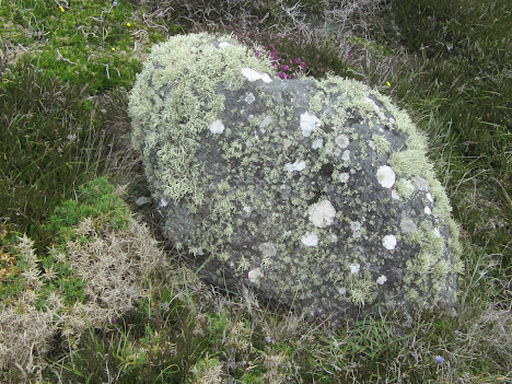
The boulder is quite small and insignificant, projecting just 30 cm above the surrounding vegetation and difficult to see because it is dark grey or black in colour and is well covered with assorted picturesque lichens and heather.  The dimensions of the well-rounded boulder are c 75 cm x 45 cm x 45 cm.  It looks very dense and heavy --rather like basalt.  Parts of the surface are quite smooth, and parts are rough and "knobbly".  I don't know of any other outcropping rocks in Pembrokeshire that look like this -- and I understand why the old geologists speculated that it might have come from Scotland or North Wales.


The best "candidate" provenance location is maybe Anglesey.  See this excellent RIGS note relating to picrite erratics on the island:
https://www.geomon.co.uk/llanerchymedd-rigs-site/

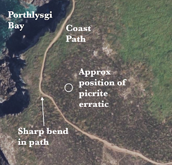
Anyway, our boulder is located on a gentle south-facing slope, and about 35m downslope from a series of prominent whitish outcrops of Precambrian volcanic rocks (the St Davids granophyre).  If you are walking south from the head of Porthlysgi Bay, on its eastern flank, you come to a point where the path swings sharply to your left (eastwards).  There are rock outcrops on the path.  There is a minor path leading out towards the tip of the peninsula, but ignore that one, and after turning the corner, leave the path and strike out across the dry heath.  You will see the boulder about 35m away -- if the gorse and the heather have not grown so high as to make in invisible!

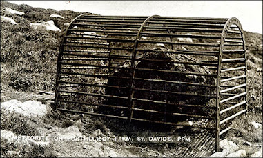
Once upon a time the boulder was in a cage, to stop people from bashing bits off it -- now it has been set free in a different position, and I can see no damage on the surface.  Let's hope it stays that way.


This is an outcrop of the St Davids PreCambrian granophyre -- white, flinty and very different from the blackish picrite erratic........

=================

Picrite is a basalt -- similar to the highly viscous lava flaws that are associated with the volcanoes of Hawaii:

Tuesday, 30 May 2023

Stonehenge Visitor Centre -- more nuanced messaging?


Thanks to Caroline Beaton for sending a photo taken recently in the Stonehenge Visitor Centre. It's good to see that the only decent book on the bluestones is displayed quite prominently, as one would expect. May it continue to sell well, as it has done over the past few years.

Caroline tells me that "there is now a panel in the interpretation centre which mentions that it is not known for sure how the bluestones came to be included at Stonehenge and that there are several theories.
So they are not saying the dragging them there from Wales theory is right!"

Caroline says that there is now a better balance in the way that EH is openly discussing the issue and candidly stating there are several theories but no conclusions. Videos also state this quite openly.

This is after all what one might hope for from the custodians of the site, who have a responsibility to offer context and summarise the latest findings and theories.

Contrast this with the recent British Museum exhibition which suggested that the word "dispute" did not exist in the English language........

Monday, 29 May 2023

Carreg Samson


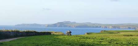
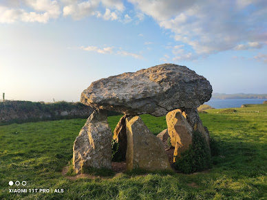
Thanks to Alun Roach for posting these pics on Facebook.  Carreg Samson is a rather splendid cromlech near the north Pembrokeshire coast -- in the most spectacular of settings.  It is supposed to have been created in the Neolithic, about 5,500 years ago.  There are six uprights and a capstone.  As we can see, the stones used in the construction are varied -- all erratics, and all used (as usual) more or less where found.  The burial chamber was constructed in a pit -- thought by the archaeologists to be the excavation pit from which the capstone was lifted. So this cromlech was built exactly where a potential capstone was found; the uprights might then have been imported from a short distance away.

That's a rather utilitarian conclusion relating to the cromlech's location -- unlike other suggestions which are a good deal more romantic and imaginative..... 

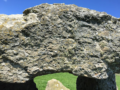
Here is a photo from Alan Hughes, showing the capstone in close-up.

The geology has not been well described -- but at least  three of the stones are made of Ordovician dolerite, and the capstone, like one of the uprights, is made of what appears to be a rough volcanic agglomerate or ignimbrite, probably derived from one of the local igneous outcrops.  This might be the rock referred to by BGS as a pyroclastic "crystal tuff" belonging to the Llanrian Volcanic Formation.

Grid ref:  SM 848335


Saturday, 27 May 2023

The Porthlysgi picrite erratic


This is one of the most famous glacial erratics in Pembrokeshire, close to the cliff edge near Porthlysgi.  Once upon a time it was in a cage, to stop people from collecting chunks of it; then it fell over the cliff edge onto the beach below; and later still it was rescued with the aid of a helicopter and replaced on the clifftop, to the north of the footpath. 

It is reputed to have come from North Wales.  Here is an excellent description of it, on the web:

ht;tps://historypoints.org/index.php?page=glacial-erratic-boulder-porthlysgi-st-davids

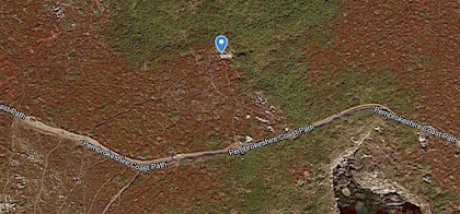
The boulder is about 30m N of the coast path, at grid ref SM 73199 23361.


Correction:  This Google location point is in the wrong position.  The boulder is further to the west, north of the coast path at grid ref SM 73108 23383

Wednesday, 24 May 2023

The fourth ancient till site in Pembrokeshire


I'm adding Traeth Mawr, Newport, to my list of ancient cemented till sites in Pembrokeshire.  The other three are:

1. Black Mixen, Lydstep

2. Ceibwr 

3.  Witches Cauldron, near Ceibwr

I have described these in other posts. The Newport exposure is on the beach, directly in front of the public car park, and for much of the year it is hidden beneath the beach sand.  But in the winter, or following storms, the ancient till -- solidly cemented -- is exposed and easy to examine.

The till is so solidly cemented with iron oxide and manganese oxide cement that you cannot extract any stones from it.  the erratics -- mostly less than 30 cms long -- are faceted and heavily abraded, and are of many different rock types. Sedimentary rocks (mostly sandstones and quartzites) predominate, but there are some igneous erratics as well.

I don't think these are recently cemented Devensian deposits, since there are fresh till exposures between the tide marks in the estuary on the inside of the sand dunes.  There is no obvious reason why till should be cemented on the outside of the dunes and uncemented on the inside -- the obvious conclusion is that the tills must be of two different ages. 

Monday, 22 May 2023

The West Angle till


I took a look at the West Angle section a couple of days ago, and while most of the section along the sea front remains rather messy and covered by vegetation, there is a good exposure of the till, with one particularly fine ORS cobble with crossing surface striations.  The striations are quite shallow, but you can feel them with a finger, and this confirms to me that this is an in situ till and not something that has been subjected to periglacial or paraglacial redistribution. Higher in the sequence, there has been a lot of redistribution, and that is why I have referred to the deposits as "stratified dark red gravelly deposits" reminiscent of the deposits so spectacularly exposed at West Dale.


I have done many posts on West Angle.  Use the search box to find the links. 

The dark blue silt and clay series is also well exposed at present, just above beach level.

One feature that is more prominent now than in past years is the rocky outcrop at the northern end of the exposure, close to the cafe.  On the foreshore there are exposures of broken Lower Limestone Shales, but in the cliff face the orange-red materials are not sediments at all (except at the top), but thoroughly rotten bedrock.  This seems to me to be the source of at least some of the "silt and clay series" which has been interpreted as interglacial, lying stratigraphically beneath the dark red till which fills an eroded gully.