THE BOOK
Some of the ideas discussed in this blog are published in my new book called "The Stonehenge Bluestones" -- available by post and through good bookshops everywhere. Bad bookshops might not have it....
To order, click
HERE

Monday, 7 March 2022

The Devils Stone, Shebbear


Thanks to Tony for reminding up of this strange stone in Shebbear, deep in the Devon countryside, 20 kms from the sea.  It's referred to in more articles as a glacial erratic, and one had better believe that, unless one insists on some other fantastical explanation.  it is reputed to weigh about 1 tonne.  It has to be turned over every year, on Nov 5th, by the church bellringers, in order to stop the Devil from escaping.  So there we are then.

There are a few photos of it on the web, and it clearly has one side that is has relatively unweathered, with quite angular edges, and another side that is very crumbly and heavily weathered.  That in itself suggests great age.

Some people refer to it as a pinkish granite, or as a "quartz boulder" -- but on close examination of some of the photos it seems to have a dark bluish colour, and looks as it it is very coarse-grained. It appears to have a red-brown weathering crust, just like many of the erratic boulders on Preseli.   Is it a dolerite or a gabbro?  Interesting........ geological opinion needed.


Rhosyfelin RIGS -- official notification


Here is the 2016 official notification / citation for Craig Rhosyfelin. It has taken a long time to get onto the official record!   It is based on its geological / geomorphological interest, but there is also a mention of the disputed quarrying hypothesis.  What is very intriguing, to all who know this site, is that Parker Pearson, Ixer and Bevins have never acknowledged, in any of the papers published between 2015 and the present day, that their ideas are disputed by anybody. That is not the sort of thing that is supposed to happen in the world of serious scientific research.......  

Say what you like about this blog, but we do at least admit to all and sundry that there are normally at least two different interpretations of anything worth thinking about...... and we have never claimed to be uniquely in possession of the truth.

https://www.pembrokeshirecoast.wales/wp-content/uploads/archive/npa_2016_april_27_20_16_rigs_spg.pdf 

Sunday, 6 March 2022

Geology of Brynberian Moor


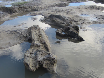
The surface of a possible moraine 200m from Brynberian Bridge

In my hunt for spotted dolerite sources, I wandered about a bit on the moor today, starting near Brynberian bridge and wandering eastwards as far as Glan yr Afon.  I confirmed that the geology map is not all that accurate.  

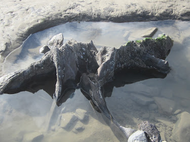
In the headwaters of the Afon Brynberian, where several streams flow down to Penllyn, therse is one exposure on the river bank which confirms that the bedrock there is Abermawr Shale, but mostly the bedrock is buried beneath a thick layer of stony till.  Around SN1046348 there is undulating terrain with many dolerite boulders; I think this is a morainic accumulation.  The boulders are heavily abraded and weathered, and most of them are dolerites -- some fine-grained and others coarse-grained and maybe best described as gabbro.  Some appear to be similar to the dark-coloured porphyritic rock with large phenocrysts which outcrops at SN103352 in the old Brynberian Quarry:


Because of the distinct whitish spots which are obvious on the outer exposed surfaces of this rock, I think we could refer to it as spotted dolerite, but the matrix is very fine-grained and almost flinty -- and on balance I think it's probably a lava..........but just a few metres away there is another outcrop of dark blue unspotted dolerite.  As at Cilgwyn, there seems to be a close juxtaposition of rhyolites / lavas and dolerites.  So there must be a sill of dolerite in the Brynberian area, which is not shown at all on the geological map.  How extensive and how thick is it?  Does it run more or less west-east and outcrop again in the Pont Saeson area?  I need to check this out.......

Bedd yr Afanc passage grave lies on the western edge of flattish plateau that runs eastwards for about a kilometre.  All around the monument there are abundant dolerite boulders scattered across the moor, but then they run out and around SN115345 there is an extensive area where there are hardly any erratic boulders to be seen.  There is a thin till, and the bedrock here is tuff and rhyolite, not mudstone as shown on the geological map. Some small gravelly exposures are seen around the steepened edges of the "plateau", and especially where the trackway towards Hafod Tydfil has been cut into the bedrock.

There are good exposures of these volcanic rocks on the east-facing "escarpment" where the streams come together near Glan yrAfon:

Fishguard Volcanics -- rhyolite and tuff -- exposed across the valley 
to the west of Glan yr Afon

Dolerite boulders begin to appear in great abundance near the footbridge near the rhyolite crag on the moor --west of Glan yr Afon

The moor (which is crossed by two north-flowing streams) is littered with dolerite boulders of all shapes and sizes.  Most are heavily abraded and weathered.  Several different dolerites are seen, including some that are spotted.  The frequency of the spotted dolerites increases as one passes eastwards towards the Glan yr Afon trackway, as indeed does the amount of "spottiness" on the boulders.  This is intriguing.  More fieldwork needed.........


 Slightly spotted dolerites from broken boulders on the moorland c 200m west of Glan yr Afon

I am now wondering whether these spotted dolerites have come from the north or the NW, from a previously unrecorded sill.   Interestingly enough, Pont Saeson -- which needs to be investigated -- is only 400m or so from Craig Rhosyfelin, a place which has received a good deal of attention already on this blog..........


Bedd yr Afanc stone sources


 I had a good look at Bedd yr Afanc today, and it was easier to examine than on some previous visits because several gorse bushes have been cleared away.  This revealed the slight mound on which the passage grave is built -- intentionally making the site drier than it would otherwise have been.

Apart from the 16 "standing" or leaning stones there are around 14 which are embedded in the turf.  As mentioned in previous posts, the stones are a mottley collection -- dolerites of various types, ashes, rhyolites and quartz blocks -- all obtained in the immediate vicinity.  there has been no real attempt to find "pillars" -- the stones are highly varied in shapes and dimensions.  I have wondered in the past why this grave site was not built a few hundred metres to the east, on the extensive and rather dry rhyolite bench that runs almost all the way to Glan yr Afon.  I now think it was built where the stones were; around the chosen site there is a litter of gabbro, dolerite, rhyolite and tuff boulders, whereas about 200m to the east there is a sudden break with a gravelly rhyolite terrain on which there are very few erratics.  I can't explain why erratics are abundant here and in the Glan yr Afon area, but not in the intervening area.  Working on it......


Close-up of a broken surface on one of the Bedd yr Afanc upright stones.  I'll call it a gabbro -- it's similar to rocks found close to Brynberian road bridge and also further east near Glan yr Afon.


Friday, 4 March 2022

Amroth submerged forest after the storms


A 6m long tree trunk currently exposed on the foreshore at Amroth

After the recent storms, at extreme low tide today on the Amroth foreshore, a vast area of the submerged forest peat beds -- around 200m x 300m -- was exposed.  Tree trunks, branches, roots and peaty beds everywhere -- but no giant elk antlers, unfortunately........  Anyway, herewith a selection of images:


Unfortunately it was very difficult today to find any sections where the stratigraphy was revealed -- since the storms occurred, sand has been washing back into the cuttings, and everything was waterlogged anyway. But I was able to see the stony layer and the blue clay here and there, and can confirm that in places the peat bed is less than 10 cm thick.


And now for something completely outrageous.........


Once upon a time......

I heard this one the other day, and since it is completely outrageous (like all the best jokes) I could not resist repeating it.  Indeed, I would be failing in my duty if I did not.  So here goes.....

=================

Once upon a time, in a country not very far away and in a time not so far into the future, a brain surgeon was looking for a new brain for one of his patients.  So he went into a brain shop to check out what was currently available.

"Ah yes," said the brain monger.  "We have a reasonable stock at the moment.  This one here, for example, is a nuclear physicist's brain, a snip at £50.  Then we have a very nice poet's brain on special offer, for just £100.  And over here we have, at the top of our range, an archaeologist's brain for a cool £1,000........."

What?" exclaimed the brain surgeon.  "You must be joking!"

"Not at all, my dear sir," came the reply.  "It's as good as new.  In fact, completely unused......"

================

Complaints -- on a postcard please -- should be sent to the Society of Antiquaries.

Thursday, 3 March 2022

The Ramsey Sound giant erratic (2)


The giant erratic on the edge of the coastal slope at Penmaen-melyn, on Ramsey Sound.  
This is the view of it, looking north.

Today I took a bracing walk from the St Justinians lifeboat station to Penmaen-melyn, to check out the famous giant erratic.  

First things first -- it's still there, where I last saw it.  Altitude c 65m asl, and visible on the skyline from all directions.

Second, it is an erratic and not an outcrop of local bedrock; it sits partly on an undulating and ice-smoothed outcrop of dark blue Ordovician micro-gabbro (much finer grained than the unspotted dolerite of Preseli) and partly on smaller erratic boulders and patches of till.  On the west-facing cliffs here there are the remnants of a small Ordovician intrusion in rocks that are otherwise tuffs of Pre-Cambrian age.

Third, it's made of grey lava or tuff  with a pinkish or purple tint in the colouring.  It's very friable and crumbly and some exposures have "stringy" structures that remind me of the pahoehoe lava which I have seen in the Canary Islands.  Other exposures look pyroclastic, which would suggest an origin in an explosive volcanic eruption. That would explain the high amount of variability in texture and colour. There are abundant fractures, vesicles  and also jagged cavities.


Above:  Close-ups of the face of the giant
 erratic.


Above:  Exposures of the dark blue Ordovician micro-gabbro (dolerite)
 bedrock near the erratic.

I measured the erratic again, and this time I estimate the weight to be nearer 70 tonnes.  But the shape is quite complex, and there is one huge crack near the northern edge of the boulder which has effectively split the boulder into two segments.  Because of the nature of the rock, the boulder does not appear to be heavily abraded or ice-smoothed, and there is not much of a weathering crust, but in places the surface is crumbling away, and there is a considerable surface cover of lichens, liverwort and grasses.

So what might be the boulder's provenance?  I cannot be certain that it has travelled a great distance, since there are Precambrian ash flow tuffs (some of them welded)  outcropping on some parts of the mainland cliffline, and a detailed analysis would be needed in order to decide whether the rock is Pre-Cambrian or Ordovician in age and to determine a likely provenance. Many of the older rocks have a lighter buff, light grey or light brown colouring.   However, there are several exposures of darker-coloured Ordovician pyroclastic rocks on Ramsey, to the NW and about a kilometre away, in the middle part of the island.  I might hazard a guess that that is where the erratic has most likely come from..........


Looking under the erratic.  We can see that it rests on several smaller erratics and on patches of local till including flint fragments and sub-rounded cobbles.