THE BOOK
Some of the ideas discussed in this blog are published in my new book called "The Stonehenge Bluestones" -- available by post and through good bookshops everywhere. Bad bookshops might not have it....
To order, click
HERE

Friday, 12 October 2018

Waun Mawn and the great spotted dolerite hunt


The diggers have gone -- but in the aftermath there are plenty of stones which can be examined


This is from the 2017 Report and funding application from MPP, on behalf of the project called
"The Welsh origins of Stonehenge" [RFF-2017-23]
Principal Investigator: Michael Parker Pearson
Professor, University College London, Institute of Archaeology


"The main discovery was that four standing stones in an arc at Waun Mawn, above a source of the River Nevern, are the likely remains of a prehistoric stone circle, most of which was dismantled and removed in prehistory (fig.6). Its 80m-long arc suggests a former diameter of c.115m, which would make it the largest stone circle in Britain except for the outer ring of Avebury. Although excavations in 2017 failed to obtain a date for the stone circle’s erection or dismantling, its stone sockets were emptied and the stones removed before the onset of peat growth. We are currently awaiting radiocarbon dates from the base of the peat, though it is likely to have started forming in the Bronze Age."

This was of course a considerable over-egging of the pudding as far as the significance of the 2017 work was concerned, but when applying for research grants a man has to do what a man has to do.........

As we have mentioned before, one of the main assumptions built into the "proto-Stonehenge" hypothesis is the supposed link between Waun Mawn and the "monolith quarries" at Carn Goedog and Rhosyfelin.  The map showing the links has been widely used.  In his lectures MPP has taken it for granted that multiple monoliths were transferred from the quarries to Waun Mawn and used there in a vast stone circle which existed for c 400 years before being dismantled and moved, lock, stock and barrel, to Stonehenge. Further, it is widely assumed that around 80 bluestone monoliths were used at Stonehenge -- and further assumed by MPP that some of them might have been used temporarily at "Bluestonehenge" as well. 

"Oh! what a tangled web we weave, When first we practise to deceive!" 

Enough of poetry -- the main point, if one has scientific inclinations, is that it is incumbent upon MPP and his colleagues to prove that maybe 50 spotted dolerite monoliths and maybe 30 foliated rhyolite monoliths were present at one time at Waun Mawn.  They carry the burden of proof, and they have to deliver.

On two separate occasions I have hunted across the dig site (which I now think involved  c 2000 sq m of excavations), looking for chips, packing stones or even "forgotten monoliths"  made of either spotted dolerite or foliated rhyolite.   I cannot be 100% certain, because I cannot know what has been found by the diggers and sent off for geological identification -- but I have not found a trace of either rock type.  (Spotted dolerite is fairly easy to spot, in the field,  since the whitish crystal clusters are more resistant to weathering then the "matrix" of the rock, making them stand proud.  So the rock surface tends to be lumpy or knobbly..... unlike the smooth surface of stones made from unspotted dolerite.)  There are plenty of  unspotted dolerite boulders,  slabs,  and pillars all over the place, and many dolerite cobbles and smaller pebbles too -- but they are all local.  There are no rhyolite pillars or monoliths, standing or recumbent.  There are some rhyolite and volcanic ash cobbles and stones, but they do not seem to be identical to those outcropping at Rhosyfelin.  In this area the ice has come in from the west and north-west; so "erratic material" from either Rhosyfelin and Carn Goedog would be a good indicator of human transport.  But there is nothing.

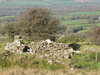
I'm not sure why this little pile of stones was left on the turf.  I assume that they have been gathered up and interpreted as "packing stones" from one of the supposed stone sockets?  They are made of dolerite, volcanic ash, rhyolite and meta-mudstone -- all quite local.

On this geological test alone, the proto-Stonehenge hypothesis is rejected.

One final thought.  Dave mentioned to me that one idea being bounced around is that bluestone monoliths might have been stored at Waun Mawn without actually being planted into the ground.  I love it!  I have this picture in my head of lovely rows of elongated bluestone monoliths on the open moorland, with 50 neatly arranged spotted dolerite monoliths over by here, and 30 foliated rhyolite monoliths over by there, with a  sales rep offering them (with free delivery, of course) to the highest bidder..........

Once these fantasies get a hold of you, there is no knowing where they will lead you.


Thursday, 11 October 2018

Abermawr -- the new Quaternary stratigraphy


This is a gorgeous photo showing the raised beach sitting on its rock bench and sealed beneath pseudo-stratified brecciated slope deposits (we used to call that  layer "the lower head"........  courtesy Pembs Coastal Photography, whose pictures are far better than mine!  The bit in the box is the enlarged section of the upper part of the parent photo.

As we can see, when we examine this image carefully, there is a wide range of rock types in the raised beach.  That almost certainly signals the incorporation into the beach of pre-Ipswichian glacially derived materials.  How else would they have got here?  From the Anglian glaciation?


So let's examine the rest of the modern stratigraphy. The full sequence looks like this:

8.  Blown sand, loess and colluvium, incorporating modern soil (c 1m)
7.  Upper brecciated slope deposits (c 2m)
6.  Reddish stained colluvium -- a pro-glacial redeposited layer (c 2m)
5.  Glaciofluvial sands and gravels incorporating flowtills (c 2m)
4  Mobile meltout till and flowtill (c 3m)
3.  Irish Sea till -- massive, with shells and carbonized wood (c 4m)
2.  Brecciated slope deposits with rockfall detritus close to broken-up cliff face (c 3m)
1.  Raised storm beach on rock bench (c 1m)

Thicknesses are approximate -- no part of the cliff shows the full stratigraphic sequence.  In general, the lower part of the sequence is in the north and the  upper (younger) deposits are best preserved in the south.  The upper brecciated slope deposits are, however, best preserved near the top of the highest cliffs, close to a convenient bedrock source.  They appear to be approximately equivalent to the reddish stained colluvium.  Together, deposits 6 and 7 used to be referred to as "the Abermawr rubble drift".

The raised beach (1) appears to be around 1m thick, but exposures are intermittent and sometimes masked by debris falls from above.  It's in a very risky position.  I tried to climb up to it once, and had to give it up, fearing for life and limb.

The lower brecciated slope deposit (2)  is clearly just a jumble of rockfall debris close to the rock outcrops, but further away there are signs of rough stratification, as seen in the exposures 50 years ago.  Now, as then, we can assume that these rough stratifications within the unit do represent some climatic oscillations, maybe over a very long period of time.

Broken rockfall debris within layer 2 -- note the heavily weathered igneous erratic boulder embedded within it.

Close-up of another heavily weathered igneous erratic in the lower slope breccia.

Lower slope breccia above the bedrock contact.  Here there is a rough stratification and the deposit is matrix-supported.

The Irish Sea till (3) has been well described in earlier posts and in the literature.  It is now known to be a lodgment till consisting for the most part of old sea-floor material from Cardigan Bay, dredged up and mixed with far-travelled materials as the Irish Sea Glacier came in from the north-west.  There are complex thrusting, folding and other internal structures.


The base of the Irish Sea till layer -- stained reddish by oxidation associated with water penetration from the  brecciated layer below. The upper part of the breccia has been churned by overriding ice and now incorporates some erratics carried by the glacier in its basal layer.


Massive Irish Sea till with an oxidised layer above, grading into flowtill (?) and mixed sediments with a lower clay content.

Above the lodgment till layer, which is grey or blue in colour when fresh, there is a complex layer with a foxy red or brown colour (the result of iron-staining) in which patches of flowtill and some detached masses of lodgment till exist in a complex relationship (4).  This can only represent the ice watage phase of the Irish Sea Glacier.

Above this, layer (5) consists mostly of water-lain materials, although some masses of flowtill are incorporated.  Collapse features and other structures indicate the existence of wasting ice masses at the time of deposition.

The junctions between layers 3, 4 and 5 are in places difficult to discern.  They must be very closely related in age.

Glaciofluvial deposits incorporating masses of assumed flowtill -- stratigraphically above the Irish Sea till layer.  Above the lighter coloured sandy layer in the centre of the photo, we can see the junction with the overlying foxy-red colluvium and redeposited till layer.

Redeposited glacial and glaciofluvial sediments towards the southern end of the exposure.  The greater the distance from the Irish Sea till exposure, the smaller the number of erratic clasts contained in the reddish silty and sandy matrix 

Colluvium with very few large erratics, near the southernmost part of the cliff exposure.  Note the rough stratification.

Recent exposures near the southern end of the cliff section reveal that the reddish stained colluvium (6)  is made for the most part from the material originating in layers 4 and 5.  The clay content is low, and this indicates that water has been of great importance in the deposition of the layer.  Sands, gravels and blown sand may all be incorporated; but the greater the distance from the Irish Sea exposure, the lower the content of large boulders and cobbles.  As one approaches the rocky crag which has recently emerged in the storm beach, the material exposed is best interpreted as a colluvial layer incorporating redeposited till and glaciofluvial materials.  As we have remarked in another post, this is remarkably similar in appearance to the "redeposited till" seen on the south Pembrokeshire cliffs, on Caldey Island, and in numerous exposures on the coasts of the Isles of Scilly.  At Westdale Bay there is a great thickness of this material, with marked pseudo-stratification.


Layer 7 (upper brecciated slope deposit) is only obvious to the untrained eye near the top of the highest part of the cliff, with signs of incorporated material from the glacial deposits below.  Most of the angular bedrock fragments have come from exposures upslope.  On the southern part of the exposure there was no adequate supply of frost-shattered or rockfall material, and so the slope breccia is not present at all.  It seems to be equivalent in age to the "redeposited till" and colluvium allocated to layer 6.  Together, these two layers comprise the "rubble drift" of earlier studies.

Layer 8, made up of blown sand, loess and colluvium, appears to be rather modern, and the modern soil has developed within it.

Blown sand and organic-rich soil horizon at the top of the cliff section.

In terms of the age of the deposits seen here, no evidence has emerged which casts doubt on the sequence which I proposed in 1965.  The raised beach is assumed to be Ipswichian or Eemian in age. The lower rockfall and slope breccia layer must span the early and middle Devensian, with subtle changes in stratification, texture and colour maybe representing environmental or climatic oscillations.  The flowtills and glaciofluvial deposits must represent the ice wastage phase, maybe over just a few centuries.  A cold episode following that (and maybe involving permafrost conditions) was responsible for the formation of the uppermost slope breccia.  This appears to be approximately equivalent in age to the redeposited till and colluvium.  The blown sand must have accumulated during the Holocene And the surface soil layer is still forming today.  

Where does the submerged forest come in this sequence?  It must rest upon the redeposited till and colluvium, and it must be approximately equivalent in age to the blown sand; maybe the sand dunes and the forest co-existed in close proximity.

Remnant of the submerged forest exposed in the sandy beach at low tide.

Sorry this is a rather protracted description!  I wanted to get it recorded while I still have the energy to do it!  It is, after all, one of the top 50 Quaternary sites in the UK, and possibly the most important in Wales, in that it holds a record of a complete glacial - interglacial cycle over a period of well over 100,000 years.


Dem crem bones -- CA overwhelmed, and BA underwhelmed......


There is more journal coverage relating to that infamous Nature article about strontium isotope dating of cremated bone fragments from Stonehenge.  But are we beginning -- not before time -- to see some signs of careful scrutiny and independent thought?

In the latest issue of Current Archaeology there is an article by Kathryn Krakowka,  accessible here:

https://www.archaeology.co.uk/articles/out-of-the-ashes-seeking-the-origins-of-the-first-people-of-stonehenge.htm

The longer, fuller article, is behind a paywall, and if it says anything interesting, somebody will no doubt enlighten us.  But  the author is clearly not inclined to delve too deeply, and what she says is based  largely on that infamous OU press release which we have already discussed.  Lots of nice free publicity for Christophe Snoeck and his colleagues.

Then we turn to British Archaeology.  The headline (on p 7 of the Nov / Dec issue) is "Stonehenge drew visitors from the very start."  Well, we knew that anyway -- almost everywhere in Britain drew visitors from the very start, some more than others.  But the author of this piece seems to have read the article, rather than just the press release, and a degree of scepticism is apparent.  Mind you, he was not so sceptical as to have ignored the "Nature" article altogether -- but maybe that would have been a step too far.  On the supposed links -- for one individual -- between Stonehenge and West Wales, he is circumspect, to say the least.  He says:  "..... prompting some archaeologists to link the people (ie those with higher isotope "signatures" ) with  the transport of the bluestones before 2500 BC...."  Later in the article he says "The data are complex to interpret, and are affected by unknown factors........"

The killer item in the piece is the map which illustrates the article.  It's supposed to show the links between three individuals and likely home areas.  The caption should have been "If anybody can see a link here between Preseli and Stonehenge, he or she has a much more vivid imagination than I do."

The author of the piece was clearly completely underwhelmed.

Abermawr, Flimston, Caldey, Carnew and Popplestones -- five of a kind

When I was at Abermawr the other day, I was struck by the similarity between the deposits near the outer end of the northern "drift cliff" and the deposits found at Flimston and Caldey in South Pembrokeshire,  at Popplestones on Bryher (Scilly Isles) and at Carnew Point, St Agnes (Scilly Isles).    Many other sites too -- but that list is enough to be going on with.  Some of these sites are inside the currently accepted Devensian glacial limit, and others are outside. That limit is going to have to be modified, as I have suggested many times on this blog.  

So what are the characteristics that these deposits have in common?  Here are some images:

Abermawr

Ballums Bay, Caldey

Flimston, South Pembrokeshire


Popplestones, Bryher, Isles of Scilly

Near Carnew Point, St Agnes, Isles of Scilly


We need to get a bit technical.  First the deposits are matrix-supported diamictons -- where cobbles and pebbles of many different lithologies, shapes and sizes are supported in a matrix of finer material.  Second, the matrix does not have very much clay in it -- unlike, for example, the Irish Sea till at Abermawr and the massive "Celtic Sea till" at Chad Girt on St Martin's in the Scillies.  Third, many of the contained stones are faceted, fractured and even striated -- good indicators of a glacial origin.  Fourth, there is a reddish or rich brown colour, indicative of oxidation and iron-staining.  As many have noticed, that characteristic is often associated with colluvium or hillwash, and with windblown deposits -- and these deposits are associated particularly with relatively vegetation-free environments in proximity to glacier fronts.

There are local variations of course.  At Ballum's Bay the deposit has the reddish colour associated with the Old Red Sandstone, across which the incoming ice passed before reaching the Carboniferous Limestone at the eastern end of the island.  At Carnew Point on St Agnes, the matrix comprises a mixture of windblown silt and colluvium and "grus" which is the product of granite weathering.  At Popplestones the reddish colluvium is ubiquitous.  At Flimston there are many beautifully rounded quartz pebbles derived from patches of Oligocene "gravels" and pebble beds which have been destroyed by overriding ice and incorporated into till.  At Abermawr there is a real mess, with the same mix of stones as in the underlying Irish Sea till and with patches of flowtill, glaciofluvial sands and gravels, colluvium and periglacial slope deposits all scrambled together.

My conclusion is that all these deposits are clear indicators of glacial activity in the neighbourhood.  But they are probably not primary tills in the positions where they were originally emplaced.  They have been mobilized in very wet (ice wastage) conditions -- moved downslope either on dead ice surfaces or on ground slopes, and redeposited a little distance away.  How far?  My estimate, in all cases, is somewhere between 10m and 50m. From what I know of ice wastage environments, transport of a deposit that still contains many of the characteristics of a primary till is unlikely to have been maintained for a greater distance except in exceptional circumstances -- for example in a catastrophic liquidised debris blow in a long gully.

So I think we are looking here at "paraglacially redeposited tills" in the modern phraseology.  

I'll do another post on the current exposure at Abermawr, which has led me to this conclusion.

==================


Here is a definition from Olav Slaymaker: 

"..........It is argued that the term ‘paraglacial’ defined as ‘non-glacial processes conditioned by glaciation’ describes landscapes that are adjusted neither to Last Glacial Maximum nor to contemporary geomorphic processes. Where a landscape is paraglacial it can be characterized in terms of rate of change and trajectory of that change. It cannot be defined in relation to glaciers (as in proglacial) or by cold-climate processes (as in periglacial). Almost all paraglacial landforms and all paraglacial landscapes are transient and transitional. An interesting challenge of paraglacial landscapes is then to determine their rates of change; how far they have advanced along the trajectory from glacial to non-glacial; and how to recognize empirically the temporal and spatial relationships between proglacial, periglacial, paraglacial and fluvial landscapes.


Wednesday, 10 October 2018

The Cnwc yr Hydd quarries -- early nineteenth century?


I have been looking at these quarries again today -- and I have found another one, on the eastern flank of Banc Du, to the north of Gernos Fach Farm.  Like the others, this is a meta-mudstone quarry.

When I put up a post a few weeks ago, suggesting that the quarries are modern, opened up to provide meta-mudstone slabs for building purposes, I was challenged on another Facebook site as follows:  "Your hypothesis.  You carry the burden of proof. Now prove it!"  Perfectly fair and reasonable, since that's what I say to our friend MPP and to various others!

I gave some supporting evidence in my earlier post:

https://brian-mountainman.blogspot.com/2018/09/the-cnwc-yr-hydd-quarries-opinion.html


So we have slabs used in abundance at the ruined cottage called Ffos-felen.  Today I looked at the ruined farmhouse at Tafarn y Bwlch, and this is what I found:


As at Ffos Felen, the slabs -- of many different sizes -- are used to level off the courses, given the rough shapes of the erratic igneous boulders used for much of the building.

Then I went off to the top Garfeth Cottage, adjacent to a free-flowing spring, and this is that I saw:


Some of the cottage walls, like the walls at Tafarn y Bwlch, were made of a mixture of dolerite boulders and meta-mudstone slabs, but the wall in the photo above is almost exclusively made of the sedimentary slabs.  There used to be mortar, but most of it has crumbled away. (Interestingly enough, this cottage was still occupied in 1946.  Our old postman was born in it.)


So there is no point in arguing or speculating any further.   The quarries are relatively modern, probably about 200 years old.  Maybe some of them were used earlier, maybe back to the Middle Ages, for the building of cottage walls -- and I suppose there is a possibility that there was some exploitation in prehistoric times as well -- given that the slabs are very easy to extract from the ground and to carry away. Another factor is the relatively dry nature of the ground underfoot -- this is dry heath and not peat bog, so the going is pretty good, even in the middle of winter.  All of the quarries are easily accessible with horse-drawn carts and sledges, and many of these wide tracks can still be traced on the ground and on satellite images. And a final factor -- all of the quarries are located high up on the hillsides and near the hill summits, so transport of the stone slabs from quarry to building site was always downhill.  Easy!

Since the last great phase of building in this area, around the fringes of the commons, was after the Napoleonic Wars, I would date the creation of most of these quarries to the period 1810-1830.

M'Lud, I rest my case........


Waun Mawn / Tafarn y Bwlch standing stone gallery

Today I was up on the mountain in positively balmy weather.  Our (no doubt short-lived) Indian Summer.  But the sunlight was perfect for pics, and here is my collection.


This is the standing stone on the perimeter of the putative stone arc or circle -- left alone by the diggers in both 2017 and 2018 


This is the most impressive stone on the moor. Standing on its own to the north of the Gernos Fach track.


This is the pair of smallish leaning stones to the south of the Gernos Fach farm track


This stone is embedded in an embankment at the side of the B4329 road a few hundred metres uphill from the cattle grid


This is the recumbent stone which  is assumed to be a part of the putative stone circle.


This is a semi-recumbent stone alongside the entrance to the 27m ring cairn (?) not far from Gernos Fach Farm


This is a small fallen stone (socket alongside) on the ridge to the west of the Cnwc yr Hydd summit

This is quite an impressive gallery, incorporating three standing stones, three leaning (all of which can be referred to as slabs), and two recumbent.  I know that MPP and his digging team think there are other recumbent or fallen stones in the arc of the putative circle, but I am not convinced by those.

But there was certainly a lot going on here.  The "stone circle" is, I think, the least convincing and least interesting feature on the moor.  There is at least one beautiful 27m embanked ring cairn, what appears to be a round house, at least a dozen old sockets or extraction pits, traces of embankments and stone walls, and something that looks as if it might be a destroyed cromlech incorporating a large quartz boulder and an infill of smaller stones between fallen supports.  The capstone has gone -- if it ever was there.  Dave Maynard thinks there is a trace of a rectangular building on the moor as well, but I have not been able to find that........

All in all, abundant signs of occupation in the Neolithic and Bronze Age.  I can see no great reason to refer to this prehistoric landscape as a "ritual landscape"  -- I reckon that people just lived here, and did whatever they had to do to survive, in those good old days.

==================

PS.  One interesting point about these and other standing stones in Pembrokeshire.  It's true that some of them are slim and elongated pillars.  But the majority are not.  Slabs, stumpy pillars and elongated boulders seem to be preferred.  Conical and triangular shapes occur as well.   For a start, these irregular shaped stones could be picked up almost anywhere, and secondly, they were probably more stable when placed securely in the ground.

PPS.  I'm pretty sure this is a standing stone too, on the roadside near Ffos Felen ruined cottage.  It's actually just 400m to the east of the proposed stone circle site.  It's  been built into a hedge at the side of the road -- and it seems much too chunky and heavy to have been brought in by a farmer in recent times just to serve as a gatepost.  Anyway, there is no hole drilled into it.......


Monday, 8 October 2018

Glacial geomorphology for archaeologists


Today I needed to scan in some of the jackets of my old books for the Society of Authors.  It occurred to me that they might be useful for archaeologists in that they are nice and simple to read -- and free of much of the technical stuff that has preoccupied glacial geomorphologists in recent years.  There is quite enough glaciology in these texts to be going on with, too.  Since all 3 books are out of print, you might be able to pick them up somewhere for a very modest price!


The one written by David Sugden and myself remained in print as the standard university text for almost 30 years, and was reprinted many times.  The other two are more popular texts.  I edited "Winters of the World" for David and Charles and Wiley,  and since the deadline was very tight I actually ended up writing several of the chapters for which the contracted authors had not delivered their texts.  Advice to future editors:  don't do it!!  Anyway, the book was very popular, and sold out quickly.  Sadly, it was never reprinted.

The one called "The Ice Age" was published by Collins and then pinched, translated and republished by a Russian publisher, and the first thing I knew about it was when somebody found a copy somewhere and told me about it.  Needless to say, they never paid me a penny -- or a ruble.......