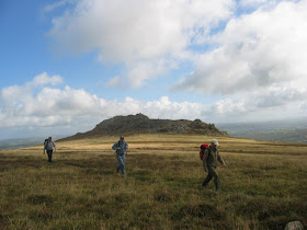
Not sure who sent this to me -- anyway, thank you, whoever you are! Wonderful colouring. This is eastern Preseli, with Foel Drigarn and Frenni Fawr seen from near Carn Gyfrwy. According to the numerical modelling, this area should have supported part of the Preseli ice cap.
On Carningli Common, with the rocky peak on the horizon. According to the modelling, Carningli might have had its own miniature ice cap or snowfield.
On the Mynydd Preseli ridge, looking westwards towards Cwm Cerwyn and Foelcwmcerwyn. Foelfeddau is the peak to tight of centre. All of this landscape would have been covered by the Preseli ice cap.
On this false-colour terrain map I have drawn a line that represents, reasonably closely, the ice cap margin thrown up by the numerical modelling.
I'm becoming increasingly convinced that there was an interaction between the Late Devensian Irish sea glacier that came in from the north-west and north, and the local ice-cap centred on Preseli. The modelling, by Henry Patton, Jonathan Lee and others in Aberystwyth, looks pretty good -- but there are some anomalies, including the apparent lack of local ice on the ridge of Carnedd Meibion Owen and a very limited northward extension of the ice cap over Brynberian Moor and the upper catchment of Afon Brynberian and Afon Nyfer. However, models are notoriously difficult to create, as the number of parameters to be fed into the computer model is huge -- and "rubbish in, rubbish out".......
But this doesn't look like rubbish to me, and the idea of a small ice cap lasting maybe 500 years seems sensible, given the recent work on Dartmoor and Exmoor. I agree with Henry Patton and his colleagues that this was probably cold-based and incapable of doing much work, and that there might have been a small area to the SW of Foelcwmcerwyn (the highest peak in Preseli) for a short time.
Here are some of the earlier posts I have put up about the Preseli ice cap:
http://brian-mountainman.blogspot.co.uk/2011/08/preseli-ice-cap.html
http://brian-mountainman.blogspot.co.uk/2012/01/preseli-ice-cap.html
http://brian-mountainman.blogspot.co.uk/2010/11/preseli-ice-cap.html
http://brian-mountainman.blogspot.co.uk/2014/12/rosebush-sand-pit.html
At present, the assumption is that the ice cap lasted for a minimum of c 500 yrs and a maximum of aboutt 2,000 years, at the time of the maximum extent of the Welsh Ice Cap -- ie around 23,500 yrs BP. There is still a debate about whether that was synchronous with the maximum extent of the Irish Sea Glacier. Work is ongoing.....
This is a fabulous image -- Foel Drygarn rhyolite crags in the foreground, and the Preseli ridge stretching away westwards. The ice cap much have covered this ridge and all of the tors and other rocky outcrops visible in the photo. Carningli is visible in the distance at top right.
On the Mynydd Preseli ridge, looking westwards towards Cwm Cerwyn and Foelcwmcerwyn. Foelfeddau is the peak to tight of centre. All of this landscape would have been covered by the Preseli ice cap.
The eastern end of the Preseli ridge, near Carn Meini. The dark peak in the middle distance is Foel Drygarn. Again all of the landscaoe in this neighbourhood must have been ice-covered.


Marvellous images. I wonder what marvels might be revealed via drone photography of the area between Stonehenge and Avebury. Anyone know of a link?
ReplyDeleteHello Brian,
ReplyDeleteGuilty as charged of the first photo, it rained just after it was taken, and once again a damp day on the dolerite.
Ah -- thank you Phil. Top photo!
ReplyDelete