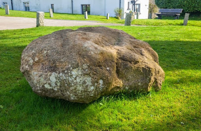
Thanks to Tony for drawing attention to this. The famous Shebbear erratic lies at an altitude of c 146m and is c 15 km from the Devon coast. It is likely to have been carried into position by an ice stream travelling from the N or NW. Over most of its surface it appears to be deeply weathered and abraded, but some breakages are apparent, and these might be of different ages. They look like glacial facets, since the fracture scars are themselves abraded. Some damage might of course have been done down through the centuries because of the village obsession of tipping it over every year on November 5th............
There is no reason at all to think that the Devils Stone might have been collected up somewhere on the coast and carried into its present position by the villagers or their ancestors....... However, there is one tradition that the stone came from Henscott, near Bradford, to the SW of Shebbear and to the west of the River Torridge. LIDAR images show that there were a number of small quarries in the area, no doubt used for local building purposes.
At both Shebbear and Henscott the local rocks are fine grained sedimentary rocks of Carboniferous age -- mostly mudstones, siltstones and sandstones.
There are still people who argue that the large glacial erratics in Devon and Cornwall are concentrated in the intertidal zone along the present coast. This is just not true, as I have pointed out on many occasions. On at least one occasion there were Quaternary ice caps on Dartmoor and Exmoor, and we know from other evidence that glacier ice from the Irish Sea Ice Stream pressed inland from the Bristol Channel; but we still do not know where the boundary between local ice and "invasive ice" might have been.


Back in the late 1960s I accompanied renowned field archaeologist Leslie Grinsell as he scrutinised parts of the North Devon landscape for evidence of barrows. It's a pity we didn't venture as far as Shebbear......
ReplyDeleteInterestingly, the river Torridge's source is 206 metres approx, Brian stated that Shebbear settlement is 150 metres.
ReplyDeleteI have checked the altitude of the place where the boulder lies, and the ground here seems to be at 146m -- the other end of the village is a bit higher -- over 150m.
ReplyDeleteI have found out that in medieval times, when geographical units called Hundreds were set up, there was a particularly large one, Shebbear Hundred, that extended, for example, to the Taw - Torridge estuary, and even included the island of Lundy, well out to sea.
ReplyDelete