I have been looking again at the gigantic multi-authored paper that rounded off the work of the BRITICE team about a year ago. Great work! Reference:Growth and retreat of the last British–Irish Ice Sheet, 31 000 to 15 000 years ago: the BRITICE-CHRONO reconstruction. Chris D. Clark et al, Boreas Volume 51, Issue 4, October 2022, pp 699-758
First published: 07 September 2022
https://doi.org/10.1111/bor.12594
I wanted to check it again, because I recalled that the authors had all sorts of problems in reconciling the models of "maximum Devensian glaciation" (the LGM) around 26,000 years ago with the evidence on the ground. In several places in the text they express their frustration at the mismatch, and I now realise that the problems lay not with the computer modelling but with the unreliable field data contained within the published studies on which they had to depend. (They did relatively little new fieldwork in the Bristol Channel and South Wales, so that did not help either......)
If we look at this map we see the predicted maximum and minimum ice front positions at the LGM. Quote: "The empirical ice-sheet reconstruction at 26 thousand years ago. The optimum ice limits (white with blue boundary) represent the favoured interpretation of the underlying data incorporating all geological, geomorphological and glaciological soft knowledge. From these optimum positions, limits were advanced and shrunk as far they could go without contradicting an age constraint to build the maximum and minimum ice limits (see inset key). These define the uncertainty around the optimum position, with the true ice limit likely to lie within this zone. Note that changes in palaeotopography and coastline position are also reconstructed."
The problem with the Bristol Channel and South Wales segment of the map is that they have (I think) fed into the computer model all sorts of data that are unreliable. I suspect that they have told the computer that there are no traces of Devensian glaciation on the coasts of Devon and Cornwall, that Lundy Island was not glaciated at the time, and that there was a strange ice-free enclave in mid and south Pembrokeshire. My article about the latter came out too late for the BRITICE work, but my suggestion that the "enclave" did not exist appears to have been accepted by everybody working in the field -- at least, nobody has challenged either my field evidence or my conclusions!
As suggested in my article, I am quite convinced that there are good grounds for supposing that:
(1) Lundy was completely covered by ice during the LGM
(2) the whole of Pembrokeshire was submerged beneath LGM ice, as was the whole of Gower
(3) Devensian ice from the west reached the edge of the Vale of Glamorgan, but may not have covered it completely
(4) some of the traces of glaciation on the north coast of Devon and Cornwall may well have been left by the LGM ice of the Irish Sea Ice stream
If these suggestions are accepted by the BRITICE authors, then the modelling of the British and Irish Ice Sheet becomes a great deal easier and more realistic. If we add the necessity of modelling the southernmost ice edge even further to the south, on the edge of the Celtic Sea continental shelf, in accordance with collected field data (published in assorted papers by James Scourse and others) we have to model for minimal ice surface gradients and lateral ice spreading. As I have argued on this blog many times, you cannot have a narrow ice lobe pushing all the way to the shelf edge in the middle of the Celtic Sea because there is no deep channel to constrain it and no flanking uplands -- so ice MUST have spread laterally (eastwards) at least as far as the Devon and Cornwall coast and well into the Bristol Channel. It all makes sense........
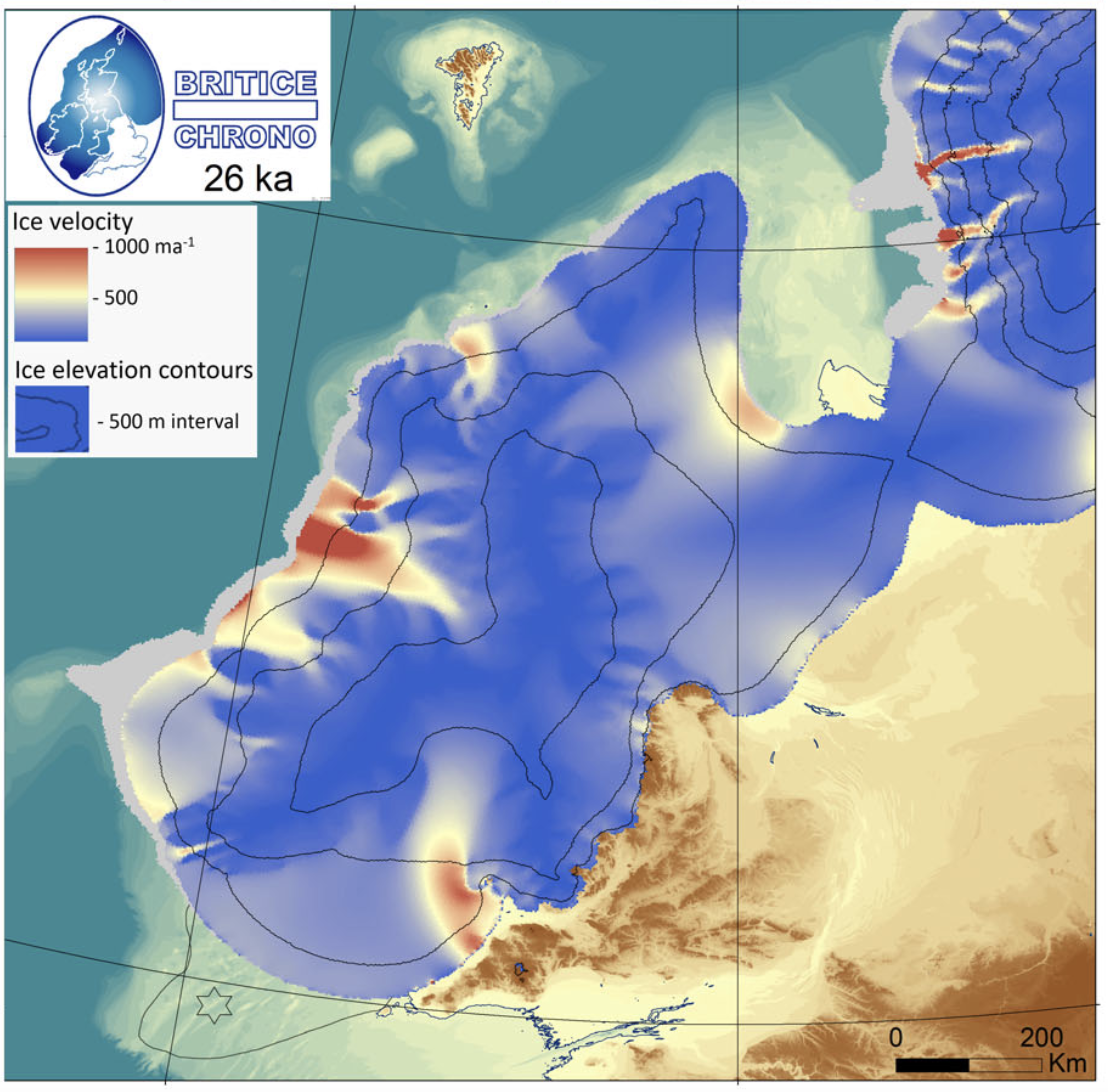
This is the map showing modelled ice velocity, showing an ice flow velocity of c 1 km per year immediately adjacent to an "ice free enclave" in Pembrokeshire. This is nonsense. No wonder the modellers said that they were thoroughly confused!
This (below) is the ice flow / ice edge scenario that best represents what happened around the LGM of c 26,000 yrs BP. It is based pretty solidly on field evidence as published in the literature.
Brian John. 2023. Was there a Late Devensian ice-free corridor in Pembrokeshire? Quaternary Newsletter 158, pp 5-16.
https://www.researchgate.net/publication/368426571_Was_there_a_Late_Devensian_ice-free_corridor_in_Pembrokeshire
Anyway, let's see what the next generation of Devensian models looks like. I'm still waiting for some sensible modelling of the Wolstonian and Anglian glaciations; that's when we will start to see some serious guidance as to the likely course of events in the saga of the bluestones.


No comments:
Post a Comment
Please leave your message here