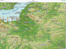
We have discussed this before, in considerations of the shape of the Anglian ice front and its extent towards the east. I am a firm believer in topographic control over glacier ice, particularly in areas near the ice edge. These images help us to understand what might have happened in the Anglian glacial episode — note that Gilbertson and Hawkins thought that the ice might have pushed as far as the Dorset Downs, but that it did not override the Blackdown Hills, the Quantocks or the Mendips. That means that glacial traces might be found around (beneath?) Bridgwater, Street, Wells, Yeovil and Glastonbury — but probably not Frome, Westbury and Warminster.
But then we have the problem of those enigmatic traces of glaciation in the Bath area — and we know that ice pressed across the coast in the area around Kenn, Clevedon, Portishead etc because glacial and fluvioglacial deposits in that area are well documented. And if, as we have suggested, the Mendips WERE overridden by ice at some stage, then the lower area to the east (centred on Frome) might well carry some traces of glaciation. Let’s call this intelligent speculation at the moment — underpinned by SOME quite strong evidence......
We have of course suggested in past posts that Kellaway may well have been right when he suggested TWO ice lobes, one heading for Bath around the northern flank of Mendip, and the other heading for the chalk scarp around Mendip’s southern edge.


No comments:
Post a Comment
Please leave your message here