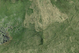
False colour computer image of the Preseli district, from Henry Patton and Jonathan Lee, with the approximate extent of the modelled Preseli ice cap added as a white line.
The red line shows the assumed extent of the Devensian Irish Sea Glacier which pressed in from the N and NW, effectively buffering against the Mynydd Preseli uplands.
I have done many posts on this topic already, but have some further field findings to report, following my visit with Chris the other day.
First, the context. We don't know that this is the case, but for simplicity let's assume that around 20,000 years ago both the Devensian Irish Sea Glacier and the Preseli ice cap reached their maximum extents at the same time. That means that -- theoretically -- there must have been a zone of contact between incoming ice and local ice along the northern flank of Carningli, and along the northern flank of the main Preseli ridge between Tafarn y Bwlch and Crymych. Elsewhere, Irish Sea ice might have pressed into depressions without having direct contact with ice from Preseli. There are a number of places where lobes of fingers of glacier ice might be expected -- for example in the Llanychaer area to the SE of Fishguard (in the lower reaches of Cwm Gwaun), in the Cilgwyn area, around Tafarn y Bwlch and Banc Llwydlos, and to the south of Crymych.
Already the "ground truthing" associated with this model is showing up some remarkably consistent and convincing field evidence. I have already described moraines at Pont Ceunant, Cilgwyn, and Tafarn y Bwlch, and there are thick fluvioglacial deposits that seem to be ice-marginal in nature near Llanychaer. Other researchers have described the glacial and fluvioglacial features near Crymych. Just as a matter of interest, Craig Rhosyfelin appears to be in the area affected by Irish Sea ice from the north and north-west, but not by Preseli ice........
Is there any physical evidence of a contact zone between Irish Sea ice and Preseli ice? I am not aware of any such evidence on the flanks of Carningli, but the long north-facing face of Preseli, between Tafarn y Bwlch and Crymych, incorporating Carn Goedog and Carn Alw, holds much greater promise. We are already pretty sure that the wide expanses of the Brynberian moorland were not affected by a large pro-glacial lake but were affected by Irish Sea Glacier ice. On the other hand, there are some sediments that appear to be lacustrine in origin beneath the 138m contour, suggesting a short-lived lake near the lower edge of the moorland. See this post:
http://brian-mountainman.blogspot.co.uk/2015/05/lake-brynberian-further-thoughts.html
I have also suggested in other posts that between Carn Goedog and Carn Alw there are traces of marginal meltwater channels which might indicate the presence of an ice edge near the 250m contour. See this image:
And see this one too, suggesting that the strange channels near the old pack road that connected Tafarn y Bwlch to Rosebush might also indicate an ancient ice margin:
http://brian-mountainman.blogspot.co.uk/2015/11/the-tafarn-y-bwlch-moraine-2.html
Lower pic: one of the postulated marginal meltwater channels above Banc Llwydlos. This one is located approx at the position of the letter "s" in the word "Channels" in the annotated photo above.
On our recent visit I noticed that close to the postulated end moraine and the "marginal channels" there are a number of deeply incised gullies around SN090330. Rather, one should say that some sections of those gullies are deeply incised and others are not. Could it be that the streams flowing in these gullies are in places flowing on bedrock (where there is little or no incision) but through thick glacial deposits (where there is deep incision)? Chris and I headed off into the wilderness to check out the hypothesis.........
What we found was interesting. We followed this gully down more or less from its source to the point where it decanted onto the open moorland below:
There were quite thick deposits (up to 4m thick) exposed here and there, but they appeared largely free of erratics and were made up for the most part of broken Ordovician bedrock shales set in a matrix of silt and clay. We did not have time to examine them properly, but I would hazard a guess that they are for the most part slope deposits which have not moved far. Could these be glacial deposits associated with a local Preseli ice cap? It's a possibility, but more work is needed......
I had hoped to find Irish Sea till, or something like it, and was a little disappointed. But we pressed on to the next gully, at a slightly lower altitude, and Bingo! There we found something that was undoubtedly a till, with a much greater range of particle sizes, varied stone types (some of which I did not recognize), and a wide range of stone shapes as well. And a sticky clay matrix.
Chris and the exposure of clay-rich till on the flank of Banc Llwydlos, close to the suggested edge of the Irish Sea Glacier.
The grid ref for this site is SN087326, and the altitude is approx 340m. This is all very intriguing, since similar till can be seen on Brynberian Moor and at Rhosyfelin. It's all slotting together. I'm now more than ever convinced that there is a thick moraine near here, and an ice-contact slope at Banc Llwydlos. If the Irish Sea ice pressed against the Preseli north slope up to an altitude of c 340m, it means that Carn Goedog must have been entirely over-ridden by Devensian ice, and it reinforces the view that the "marginal channels" were used by meltwater at a time when the ice surface was wasting away. It also means that the crags of Carnedd Meibion Owen and Carningli were in all probability covered by Irish Sea ice during the Devensian glacial episode.
These are exciting developments. There is more work to do.......


No comments:
Post a Comment
Please leave your message here