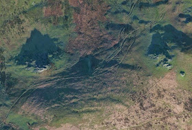
There are some amazing new images on North Pembrokeshire on the web -- from satellite imagery obtained earlier this year -- presumably in the early spring. These have nothing whatsoever to do with Stonehenge or the Ice Age, but I thought I'd share them anyway! With the sun very low, and with long shadows, lots of landscape details stand out clearly.
The upper image shows the old Drover's Road (used in particular in the late 1700's and early 1800's) running between Carn Goedog and Carn Breseb, en route towards Carn Alw and Eglwyswrw. Many thousands of animals must have been driven this way, heading from the rich farmlands of Pembrokeshire towards the growing industrial towns of the Midlands. The trackways are quite spectacular.
The lower image is a classic one, showing Hafod Tydfil, on the northern flank of Preseli. Any farm in Wales which has "Hafod" in the name must have started as a summer settlement, used for grazing in the summer months when the land close to the home farm (or "hendre") was needed for the growing of crops. The Norwegian saeter was very similar, as were the transhumance cottages in the Alps. Hafod Tydfil must have started as a very small hovel, but eventually a farmhouse was built here, and it was farmed as a viable unit for many years. Ronald Lockley lived and farmed here for a while after WW2. Now the farmhouse is ruinous, and the fields are just used as permanent grazing -- but the place still stands out as an "island" of cultivation in the midst of the wilderness. I was caught in a thunder storm here once, and was stupid enough to take shelter near that big clump of trees.......


No comments:
Post a Comment
Please leave your message here