MPP and his tribe have announced their intention to investigate a "possible dismantled stone circle" somewhere in North Pembrokeshire, while they are here on their current season of fieldwork. At the moment they are digging in their "Neolithic quarry" at Craig Rhos-y-Felin (Pont Saeson), but when they have found the "quarry" and finished there, they will probably move across to Waun Mawn, a couple of miles away, and start looking for stone sockets........
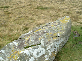
It can only be Waun Mawn -- so I would put my bottom dollar on that. Here are pictures of the three stones that will be the focus of their attention:
NP Figgis and I think that it is unlikely that there ever was a stone circle here. At the site in question, on a broad bench on the hillside, there is one standing stone, flanked by two quite large recumbent stones, with one further smallish stone just sticking up through the turf. You cannot fit these stones onto a line or onto the circumference of a circle -- but if you want to stretch your imagination to extraordinary limits, you might imagine a truly enormous circle maybe even larger than the original Stonehenge earthwork. Or maybe you could draw a circle with a diameter of 110m (the same size as the earliest circular enclosure at Stonehenge) -- or maybe with a diameter of 86m (the same size as the diameter of the ring of Aubrey Holes.)
So the MPP theory is probably that there was once a very large stone circle here, maybe with 30 or more large standing stones in it, and that this stone circle was for some reason dismantled with the intention of taking it to Stonehenge. However, for some reason 3 stones got left behind. The Aubrey Holes were dug, ready to receive the stones -- but they never arrived.......... My God, the story becomes more exciting by the day!! MPP will probably correct me if I have this all wrong.....
As I have said, the stones hereabouts are all rather coarse (unspotted) dolerite -- so the hunt will be on to discover whether the Waun Maun stones can be matched up petrographically or geochemically with anything at Stonehenge -- either in the bluestone assemblage, or in the debitage.
The first thing the team will do is to decide where some of the other stones in this imaginary circle might have been, and then to hunt for the sockets. Will they find them? Well, if you want something badly enough, you will probably find it.......
Remember folks, you read it here first.


Barrows and Standing Stone are Neolithic place markers that show tracks to settlements or places of interests like water springs, quarries or temples.
ReplyDeleteStone Circles are intersection points were multiple paths meet and the stones align with these ancient pathways.
To find out if this is a Standing Stone or the remains of a Stone Circle you will need to plot out all the pathways to see if a single path (standing stone/barrow path) or multiple paths (5 or more) go through this site.
Not exactly rocket science, if you remember that what you see today, is not how it looked in the Neolithic period - hence paths without markers as suggested by Geo Cur in previous comments, would not exist as they would become overgrown in a short period of time.
Hence the placing of these markers on 'high ground' RELATIVE to there environment.
RJL
Robert -- I have to give you credit for your utter conviction and certainty about everything!! Maybe it's the hat that does it.
ReplyDeleteYou are of course quite wrong. All of these stones are on low ground relative to their environment (whatever that means).
RJL , two of the major tracks in prehistoric southern England are the Ridgeway and Icknield way can you think of any standing stones on their route ? Or any prehistoric route over a stretch of miles where standing stones mark the way.
ReplyDeleteTheir are swathes of the country where you will not a find a standing stone does this mean that these areas were trackless ?
In some cases standing stones are clearly markers , they are relatively common on the 18th C Wade roads of Scotland and the some does apply to some from earlier periods but when there are a pair or a group that clearly have no relationship to tracks e.g. Dunruchan it is apparent that there is more to the problem than something as simple as markers .
Tracks are maintained by their use ,whether animal or human or both , and utility and even in areas where stone is available their is no need to to point to the fact that your are on the track .
To be fair, MPP and his Stonehenge Riverside Team have recent experience of identifying a dismantled stone circle, namely the so-called "Bluestonehenge" at the bottom of Stonehenge Avenue close to the River Avon.So they will again be looking for evidence of stone sockets.Incidentally, at the end of the previous Season of digging, they had no notion that they might find such a dismantled circle.
ReplyDeleteHmmm ... I find the Bluestonehenge stuff very unconvincing, as I have explained on this blog. Far too many assumptions and blind leaps of faith, based on far too little evidence. I still remain to be convinced that there were any bluestones there at all....
ReplyDeleteHow do you know a certain route is prehistoric and if so can i get a copy of that map?
ReplyDeleteIn reality the only routes we know are roman or iron age some 3000 years later!!
If we didn't have a need markers on routes why did we use mile stones ?
The lack of historical knowlegde and the inablity to picture the forest that covered our environment is astonishing!