In my post of 24 March 2011 I examined the evidence for tors of different shapes and histories and pondered on their relationship to the Devensian ice limit in West Wales. Info here:
http://brian-mountainman.blogspot.com/2011/03/teetering-tors-damaged-tors-and-denuded.html
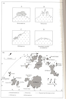
Then I came across this map by James Scourse in which he refers to 4 different tor types in the Isles of Scilly and relates them to the glaciation limit (again assumed to be Devensian). It's interesting and persuasive work (in the Geol Conservation Review volume for SW England, p 265). James maps the 4 different tor forms and shows that the smoothed and rounded tors are basically within the ice limit and the other types are outside it -- so although this was all very close to the ice edge, the ice still had enough strength to erode away the more fragile elements of the tor morphology.
This isn't an exact science -- and I wouldn't mind betting that there is a degree of subjectivity (and maybe even bias?) in deciding which category any particular tor should fall into. So the map may or may not be 100% reliable. No matter --- the broad principles of the exercise are fine, and the map does tell us something quite interesting about the capacity of a glacier to modify the landscape quite dramatically very close to the ice edge, even if the ice was only present there for a few years.

Brian,
ReplyDeleteI have been puzzled for a long time with the spots on the 'spotted dolomite' bluestones. What is the composition of the white spots? Can it be 'calcium splatter' from chalk? And are these white spots 'surface spots' only? Are they uniformly all around the bluestone or primarily on some sides of it? Are these due to 'weathering' and geochemical processes? What are the current explanations for these?
Also, in a previous post (“Precision in provenancing“) you have a photo (“coast near Dinas”) of a coastal landscape with very interesting coloration patterns. Just last night I was watching a documentary on the eruption of Mt. St. Helen's and on the inside of the crater are strata exposed from earlier eruptions. The coloration of these strata reminded me of your photo. Have these been studied to determine the geological origins of that coastal landscape in your photo?
Very curious,
Kostas
Kostas -- this is all in the book and on the site. Spotted dolerite (not dolomite) has been well known as an unusual form of dolerite for well over a century -- characterized by large or small spots coloured white or pink. The spots are normally referred to as felspar (feldspar) crystals but it now appears that they are more complex than that. The spots are in the rock -- nothing to do with weathering.
ReplyDeleteThat photo of spectacular colourings in the coastal cliffs west of Dinas -- the rocks are Fishguard Volcanics, and there's a lot of chemical colouration by copper, iron and other minerals presumably precipitated out at some stage subsequent to the volcanic eruptions.
Oops! I was way off the mark on this one! Have no trouble admitting I am wrong when I am wrong! Thanks, Brian, for clarifying this 'curiosity' for me!
ReplyDeleteKostas
No problem, Kostas. You are not the first person to confuse dolerite with dolomite....
ReplyDelete